Complex Coastal Resiliency Project Requires More Review and Input
Comments to the City Planning Commission
Since our involvement with the Rebuild by Design global competition in 2013, the Municipal Art Society of New York (MAS) has advocated for implementable resiliency solutions through the combination of technical expertise and effective community engagement. Before we can support the proposal, the East Side Coastal Resiliency Project (ESCR) must include specific mitigation measures to effectively address environmental impacts during construction, provide sufficient details on how the project would be integrated with other coastal resilience plans, and demonstrate true community input in planning and design.
ESCR seeks to reduce coastal flooding vulnerability and risk while enhancing waterfront open spaces and waterfront access. It is the first of many planned, large-scale resiliency projects to be advanced in the wake of Hurricane Sandy. It was touted in One New York: The Plan for a Strong and Just City as a “new model for integrating coastal protection into neighborhoods.” While we recognize the complexity of ESCR and the challenges in coordinating such a massive effort, we call on the City and its partners to address our comments and work towards garnering true support from the affected communities and arrive at long-term, comprehensive resiliency protection.
Download Testimony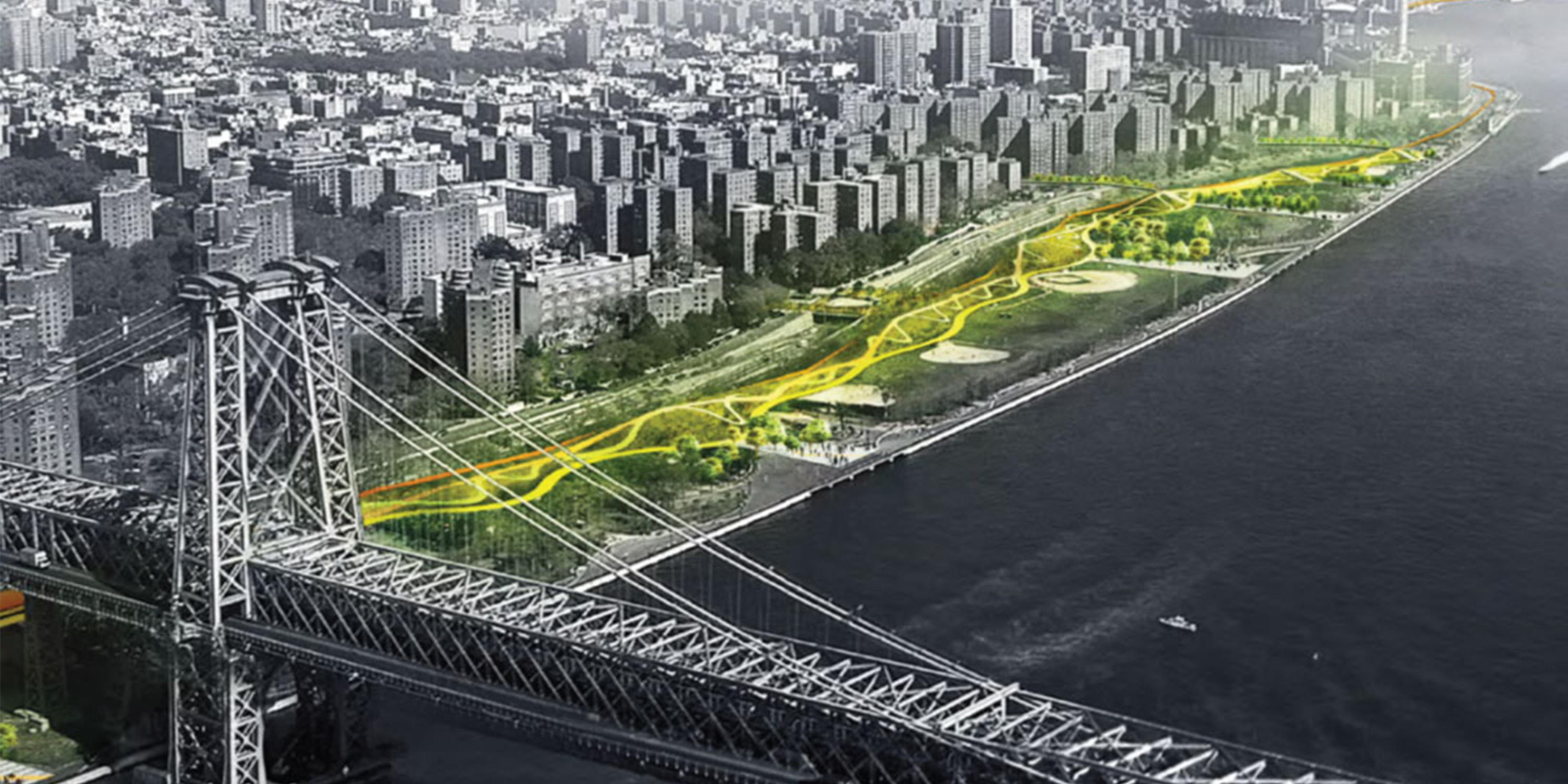
Background
In Hurricane Sandy’s aftermath, MAS joined a consortium of organizations on the Rebuild By Design taskforce that chose the original Big U project as an innovative solution to coastal flooding and resiliency in Lower Manhattan. 1 The Big U focused on flood protection systems extending along the Hudson River from West 57th Street through Battery Park to East 42nd Street along the East River. Federal funds were allocated for the design and construction of the Montgomery Street to East 25th Street section, which is coterminous with the ESCR project area.
For four years, the East River communities, specifically those in Manhattan Community Boards 3 and 6, were engaged in the planning and design of the ESCR segment of the Big U. However, following Community Board review in the 2018 ULURP, the City abruptly changed course to avoid staging the construction process and presented the current ESCR plan without any public input. At the same time, project funding was increased to $1.45 billion, including $338 million in a United States Department of Housing and Urban Development (HUD) Community Development Block Grant-Damage Recovery grant (CDBG-DR).
In October 2018, the City released the ESCR Final Scope of Work, triggering the current environmental review process. On April 5, 2019 the City released the Draft Environmental Impact Statement (DEIS), which includes the ESCR as Design Alternative 4 or the Preferred Alternative, and the original plan as Alternative 3, and certified the project for ULURP.
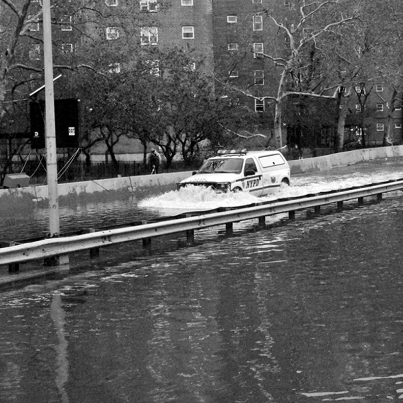
MAS was not alone in asserting that the late-in-the-game project change undermined hard-fought community partnerships and bred substantial mistrust of City agencies and the planning proposal itself. We share concerns over the new design; the absence of a detailed mitigation plan for addressing the temporary but significant loss of East River Park, Murphy Brothers Playground, Stuyvesant Cove Park, and Asser Levy Playground, and access to the East River during the three-and-half-year construction period; the lack of clarity regarding interim flood protections during construction; and the level of long-term flood protection provided by ESCR once it is completed.
Comments and Recommendations
Project Site
The Project Site is divided into two areas: Project Area One and Project Area Two. Project Area One is approximately 61 acres and extends from Montgomery Street on the south to the East River Park on the north. At 46 acres, East River Park is the predominant feature in the area and is one of the city’s most heavily used parks. It serves a population of approximately 160,000 residents and comprises 54 percent of the 85 acres of open space in the Project Area. The park includes the East River Promenade, the East River Bikeway, passive seating, lawn areas, two playgrounds, water fountains, picnic and barbeque areas, an amphitheater, eight baseball fields, two-and-one-half basketball courts, two volleyball courts, 12 tennis courts, three soccer fields, a track, and athletic fields.
Project Area One includes five pedestrian bridges across FDR Drive and four major housing developments (Gouverneur Gardens Housing Corporation, East River Housing Corporation, and the NYCHA Baruch Houses and Riis Houses). The area also includes the Lower East Side Ecology Center in the historic former Engine Co. 66 Fireboat House near the Williamsburg Bridge, used for administrative offices and programmed public activities.
Project Area Two is approximately 21 acres and extends generally from East 13th Street to East 25th Street. It is dominated primarily by highway, streets, utility uses, parks, open space, and community facility uses. The area contains Con Edison’s New York East River Generating Station and several playgrounds and parks, including the 2.44-acre Asser Levy Playground at the northernmost area, Captain Patrick J. Brown Walk (1 acre), Stuyvesant Cove Park (1.9 acres), and Murphy Brothers Playground (1.27 acres).
The Proposed Project – “Preferred Alternative”
The New York City Department of Transportation, Citywide Administrative Services, Department of Environmental Protection, and Small Business Services, collectively the City, seek ULURP approvals, the acquisition of eight easements on non-City owned properties (to access infrastructure), and a number of Zoning Resolution text amendments to permit the Proposed Project. Overall, the Proposed Project would remove all existing structures, soil, and subsurface of East River Park, raise the majority of East River Park up to nine feet above its current height, move all coastal resilience infrastructure east to the water’s edge; fully reconstruct East River Park and three other parks; and replace all trees (as many as 981) and vegetation in the park. The Proposed Project includes numerous design components and improvements, including but not limited to the construction of floodwalls, levees, closure structures, and substantial subsurface drainage and water management infrastructure.
Specific proposed infrastructural elements include constructing parallel sewer conveyance drainage pipes at nine locations, replacing three access bridges, and constructing a flyover bridge for much-needed enhanced bike and pedestrian access at the 13th Street/Con Edison station pinch point. Through these actions, the project would improve the city’s greenway network and north-south connectivity. The project will also reduce potential for flooding, wave damage, and the resulting scouring and erosion.
Improvements to existing facilities, amenities and infrastructure under the proposal include the reconstruction of Pier 42 as a 2.6 acre-public space with gardens, playgrounds, a comfort station and shared path; the creation of the Lower East Side Ecology Center (LES Ecology Center) Compost Facility; and renovation of the existing Fireboat House where the LES Ecology Center administration offices are located.
Project construction will require 600,000 cubic yards of fill to be delivered at an average of three barge trips per day. Excavation and grading will disturb 82 acres. Construction is expected to begin in 2019. East River Park would be completed in 2023 and the Proposed Project would be fully operational by 2025. In comparison to the original plan, construction would be reduced from five years to three-and-one-half years.
Process, Coordination, and Public Participation
As mentioned previously, the public had no direct input in the planning or final design of the proposal currently under review. Considering the magnitude of the project, the importance of East River Park and other open space resources, and the expected environmental impacts, we find this unacceptable. Therefore, it is imperative that the City actively and comprehensively engage the local community in the project planning and design. To accomplish this, we agree with the recommendations from Manhattan Borough President Brewer and Community Boards 3 and 6 that a project community “Task Force” comprising stakeholders, civic leaders, area residents, and local business owners be formed to help coordinate the effort. To ensure better transparency and effective community input from project construction through operation, the group would coordinate with the City and Community Boards 3 and 6 on design, scheduling, timelines, construction, and post-construction maintenance.
Purpose and Need
The primary purpose of the ESCR is to increase resiliency along the East River to protect property, vulnerable populations, and critical infrastructure. The area that would be protected includes the current 100-year special flood hazard area and areas within the projected 100-year flood hazard area in 2050. This takes into account the 90th percentile projection of sea level rise and is consistent with the extent of inundation experienced during Hurricane Sandy. 2
Although the 100‐year flood is used as the current critical benchmark for addressing flood resiliency, “the record surge brought by Hurricane Sandy emphasized the need in follow‐up research to look beyond the 100‐year flood to assess more upper end future flood possibilities,” according to the New York Panel on Climate Change 2019 Report. 3 In addition, at the July 31st City Planning Commission ESCR ULURP public hearing, a Department of Design and Construction representative stated that under the Preferred Alternative, there is capacity to raise projection measures an additional two feet, thus providing flood protection consistent with 2100 100-year-flood hazard predictions.
For a project of this scale, importance, and level of investment, protections should extend as far in the future as practicable. Therefore, MAS urges the City to adopt the 2100 100-year-flood estimations as the baseline height and level of flood protection for the ESCR design. Additional potential capacity to protect to higher flood level predictions in the future should also be incorporated. The project scope and DEIS be must be revised to address this important change.
Indirect and Cumulative Effects or Project Alternatives
In addition to the ESCR, the City is engaged in the planning for the Lower Manhattan Climate Resiliency Plan (LMCR), another significant resiliency infrastructure and protection project within the former Big U footprint. The LMCR, which is listed in the ESCR DEIS as a No-Build project, shares the southern boundary of the ESCR at Montgomery Street. According to New York City Economic Development Corporation (EDC), construction of the LMCR-Two Bridges project is estimated to begin in 2021, which coincides with the ESCR construction timeframe. 4 The DEIS also states that the LMCR-Two Bridges Project will be subject to its own separate environmental review.
From a comprehensive environmental planning standpoint, this is problematic. Because of the shared overall resiliency purpose, site proximity, and overlapping wetland permitting and construction timelines, we believe the impacts and benefits of both projects should be evaluated cumulatively. Therefore, the ESCR DEIS should in the very least evaluate how the two plans will interconnect on a planning and regulatory level, and most important, on improving resiliency and flood protection in the area for the long term. The evaluation should address connectivity of the waterfront esplanade, comparative levels of flood protection, infrastructural tie-in points, and interim protection measures before and during construction. The DEIS should also include a discussion on the potential cumulative environmental impacts and mitigation measures. Ideally, these plans should be coordinated into a singular, overlapping and integrated strategy that provides consistent levels of flood protection and creates economies of scale in terms of cost and regulatory approvals.
Open Space
The importance of East River Park, the surrounding playgrounds, and access to the East River to the 157,263 residents in the Study Area cannot be overstated. With a paltry 85 acres of open space, the ESCR community is already woefully underserved. The area has a mere third (0.54 acres per 1,000 residents) of the citywide median of 1.5 acres per 1,000 residents, and falls far short of City’s goal of 2.5 acres of open space per 1000 residents. For active open space, the ratio per 1,000 residents is even worse–a paltry 0.34 acres, slightly more than a fifth of the citywide average. Manhattan Community District 6 itself has the lowest amount of open space per capita of any community district in New York City (0.18 acres per 1,000 residents). 5
The ESCR Project Area also has a substantial low-income and older population. According to the DEIS, 21.4 percent of area households are categorized as low-income. In comparison, 20.3 percent of the citywide population is living at or below the poverty level. There are over 28,000 residents–17.5 percent of the area’s population–living in 26 New York City Housing Authority (NYCHA) developments in the Project Area. Demographically, 55 percent of the area’s population identify as people of color. 6 Based on these conditions, we find the DEIS claim that “no minority or low-income communities or children would be disproportionately or adversely impacted” by the project highly questionable. The area is also home to a number of retirement communities in co-ops and affordable housing apartment complexes. Nearly 26,000 residents, or 16.7 percent of the area population, are 65 years and over. 7
During the project ULURP process, many community members expressed the need for increased parks and open space in the Project Area. Based on the lack of open space resources, and the disproportionate number of low-income, minority, and older residents, we believe the City must work with the community to find opportunities for additional open space after the ESCR is completed. To address this, we urge the Applicant team to coordinate closely with NYC Department of Parks and Recreation, Department of Education, NYCHA, community groups, and non-profits such as the Trust for Public Land and New Yorkers for Parks to work on plans for the creation and activation of new parks and open spaces.
Further, MAS questions the population estimates used to determine open space ratio projections. The DEIS states that Proposed Project would have a direct effect on East River Park, Stuyvesant Cove Park, Captain Patrick J. Brown Walk, Murphy Brothers Playground, and Asser Levy Playground, but would not introduce a significant new user population. It is not clear if the new population from the proposed projects under the Two Bridges Large Scale Residential Development (Two Bridges LSRD), currently under environmental review, is included in the open space analysis. The projects under the Two Bridges LSRD, which are expected to be completed by 2021, are within Census Tracts 2.01 and 6, which are in the ESCR Study Area. The Two Bridges plan proposes four new high-rise residential towers, the closest of which (259 Clinton Street) would be approximately 500 feet from the southern boundary of the ESCR. It can be expected that a portion of the additional 6,000 new residents under the Two Bridges plan would utilize East River Park. Therefore, the revised DEIS must clarify if the additional population has been included in the analysis.
Construction Impacts
Open Space
With the closure of East River Park and the surrounding playgrounds the amount of publicly available open space in the Project Area would be reduced by as much as 50 percent during the three-and-one-half-year construction period. Without use of East River Park alone, area open space would be reduced to less than one-fifth of the citywide average. There are also no guarantees that the highly optimistic construction period would not be delayed. It is clear that project construction will have a tremendous negative impact on a community that is grossly underserved by open space and disproportionately lower-income and older.
As one of the city’s most highly used parks and key link in the greenway system, the loss of ball fields, running track, pathways, picnic areas, playgrounds, amphitheater, and other components will have a drastic impact on recreational activities and overall quality of life of residents and park users. Therefore, it is paramount that the City minimize the disruption and mitigate the substantial construction impacts. To this point, the level of detail and commitment to specific mitigation for construction impacts, particularly regarding open space, is demonstrably insufficient. For the first step, with public safety and increased transparency in mind, the Applicants must coordinate with the project Task Force, property owners, residents, community stakeholders, and Community Boards 3 and 6 regarding specific construction activities, affected areas, and schedules.
Phased Construction
We concur with those who have repeatedly called for the reconstruction of East River Park and other playgrounds to be phased or staggered, enabling partial public access during all stages of construction. We recognize that this effort will require substantial coordination and planning. To better facilitate construction phasing, we expect the City to be fully engaged with the Task Force and Community Boards 3 and 6. We also request that the DEIS be revised to include an evaluation of a “Phased Construction Alternative” that would potentially replace the “Preferred Alternative”.
With phased construction in mind, it is incumbent upon the City to effectively mitigate to the extent practicable the loss of recreational facilities (i.e., ballfields, running track, playgrounds, tennis courts etc.) and the East River greenway/shared-path during construction. The Applicants must conduct substantial outreach with affected sports leagues, organizations, and other park users to create a plan for the use of alternative facilities, sites, and pedestrian/bicycle path routes. As part of the outreach, we urge the City to coordinate with the Trust for Public Land to identify potential new open space as part of the mitigation measures. This effort should include identifying nearby public school grounds and mid-block spaces on area streets with relatively low traffic. The use of NYCHA property should also be considered to create new playgrounds and recreational facilities to off-set impacts. The overall mitigation plan should include, but not be limited to, information on scheduling, timelines, permitting requirements, transportation for specific youth groups and leagues, and a public wayfinding/signage plan. It is critical that this information be disclosed in the FEIS.
Noise
Construction noise will have severe impacts on area residents and community facilities (i.e., hospitals and schools). The DEIS predicts that noise would reach up to the mid-80s in decibels (dBA) during daytime construction. This is the equivalent of the noise generated by heavy trucking from a distance of approximately 98 feet. We urge the City to use quieter equipment models for large noise-producing construction equipment (cranes, generators, compressors, and lifts) to reduce construction noise by 10 dBA, as described in the DEIS. Details on specific equipment and measures to reduce noise must be included in the project FEIS.
We agree with the Manhattan Borough President’s recommendation that specific quieter construction methods (i.e., press in pile vs. standard pile drivers) and equipment must be incorporated into all Requests for Proposals associated with construction work bids. During the entire construction phase, we also request that the City make available all noise monitoring information regarding residential buildings and community facilities in the Project Area on the project website. This information should include construction timing and feedback systems (i.e., website, contact information) for community complaints.
Transportation
The East River shared-use path not only serves local residents; it is also used by thousands of commuters and recreational enthusiasts as part of the East River Greenway that extends from the Battery in Lower Manhattan to East Harlem. According to NYC DOT, nearly 2,100 cyclists used the shared-path on weekdays and nearly 2,000 used it on weekends during daylight hours in 2018. Usage is expected to rise annually by 5 percent. 8
As mentioned previously, construction of the Proposed Project will temporarily close this important thoroughfare and transportation route, severely hindering connections to other areas of the region for local residents and commuters. Because of the potential significant adverse impact on area connectivity, the City must work with DOT, project Task Force, and area stakeholders to come up with a detailed alternative passage plan for bikers and pedestrians during project construction and include the details in the FEIS.
Hazardous Materials
Due to historic industrial and manufacturing uses (i.e., gas stations, auto repair shops, and the ConEdison facility between East 13th and East 15th Street), the study area contains high levels of contamination, particularly in the northern section. Former manufactured gas plants (MGP) left petroleum waste and gas production byproducts in the soil and groundwater, including coal tar, fuel, gasoline, and volatile organic compounds. The area also contains asbestos, lead-based paint, pesticides, herbicides, and heavy metals.
According to the DEIS, MGP recovery wells will be installed prior to project construction activities to reduce further contamination. A major concern is that demolition and excavation (i.e., Pier 42, the flood protection systems along FDR Drive, and other activities within close proximity to the East River) have the potential to disturb contaminated soil and other materials. Therefore, it is imperative that the highest level of protection is employed in these areas to prevent the migration of contaminants on land and within the East River.
Because of the critical nature of these procedures, for full disclosure, we request that the FEIS include all documentation related to the remediation of hazardous materials. This includes but is not limited to correspondence between the Applicants and all environmental oversite agencies (i.e., Environmental Protection Agency, New York State Department of Environmental Conservation, New York City Mayor’s Office of Environmental Remediation), an asbestos-containing materials study, Remedial Action Plan, Site Management Plan, Soil Management Plan, and a Construction Health and Safety Plan.
Historic and Cultural Resources
The Engine Co. 66th Fireboat House (Fireboat House), located at the south end of East River Park near the Williamsburg Bridge, is a historic property within East River Park. The Fireboat House is one of the last physical structures connecting the East Side of Manhattan to its maritime past. Since 1998, the Fireboat House has housed the LES Ecology Center, which hosts ecological stewardship-related programming and composting services on-site.
According to the DEIS, the Fireboat House will be renovated by NYC Parks. The work includes constructing an Americans With Disability Act-compliant entrance ramp. The DEIS also states that Fireboat House elevations would not be raised under the Proposed Project. The DEIS does not provide details on how the Fireboat House would be protected and preserved during construction, whether it would be in use during construction, and how the new facility would be protected from flooding after the Proposed Project is completed. We expect all of these issues to be addressed in the FEIS.
The Proposed Project also involves the creation of a new LES Ecology Center Composting Facility. However, the DEIS does not include details about interim provisions for addressing administrative offices, programming, and composting services during ESCR construction. These issues need to be clarified in the FEIS.
In addition, the New York City Office of Management and Budget (OMB) is the lead agency responsible for compliance with NEPA and Section 106 of the National Historic Preservation Act. The MAS and New York Landmarks Conservancy are consulting parties in this process. There are 17 properties within the Study Area that are either listed on or eligible for the National Register of Historic Places. Eleven of these properties are with 90 feet of the Project Site and require protection during project construction. These include:
- The FDR Drive (National Register-eligible)
- Williamsburg Bridge (National Register-eligible)
- Engine Co. 66 Fireboat House (National Register-eligible)
- Gouverneur Hospital (National Register-listed)
- Gouverneur Hospital Dispensary (National Register-eligible)
- A portion of the Vladeck Houses within the Lower East Side Historic District (National Register)
- Bernard Baruch Houses (National Register-eligible)
- Asser Levy Public Baths (National Register-listed, New York City Landmark)
- Jacob Riis Houses (National Register-eligible)
- Stuyvesant Town (National Register-eligible)
- Peter Cooper Village (National Register-eligible)
According to the DEIS, each property will be subject to a Construction Protection Plan (CPP) in consultation with Landmarks Preservation Commission (LPC) and State Historic Preservation Officer (SHPO) and following Department of Buildings guidelines (TPPN #10/88). The CPPs will be designed to address inadvertent construction-related damage from ground-borne vibrations, falling debris, collapse, dewatering, subsidence, or construction equipment. They are also expected to include provisions for protective measures (i.e., monitoring) to be implemented during project construction to detect vibration or other physical impacts. For full disclosure and clarity, we request that the FEIS include the CPPs, details on the CPP public review process (i.e., timelines, plan requirements, standards for review and approval), and related correspondence with LPC and SHPO.
Natural Resources
Construction of the Proposed Project will involve significant disturbance in the East River, a tidal wetland regulated by the New York State Department of Environmental Conservation (NYSDEC) and U.S. Army Corps of Engineers (USACE). In-water construction activities include the use of construction barges, installation of shafts and footings to support the proposed shared-use flyover bridge, reconstruction of sewer outfalls, demolition of the East River bulkhead, construction of a new cut-off wall, demolition of existing and creation of new embayments, and demolition of existing piles. In total, these activities are expected to affect 24,085 sf (0.55 acres) within the East River. The extent of the disturbance has the potential to adversely affect water quality and wildlife.
Despite the impact in the East River, the DEIS does not include commitments regarding mitigation measures. Instead, the Natural Resources assessment repeatedly states that “all adverse effects to NYCDEC and USACE regulated tidal wetlands would be subject to the regulatory permitting process” and would be mitigated in accordance with permit conditions. Therefore, for full disclosure, we request that the FEIS include the joint Federal and State wetland permit application, Essential Fish Habitat study, and other associated documentation related to mitigation. We also expect the FEIS to include details regarding City commitments in utilizing wetland mitigation credits from the EDC-operated Saw Mill Creek Wetland Mitigation Bank on Staten Island.
Overall, the Proposed Project would disturb an area of 82 acres. On-land construction activities include excavation and grading of soils, soil transportation and storage, tree and vegetation removal, reconstruction of shared-use bike and pedestrian path and various drainage components. With respect to full disclosure and effective public review, we request that the FEIS include a landscape restoration plan, including details (i.e., type, size, location etc.) of all trees and vegetation that will be restored. In addition, we request that the FEIS include the Stormwater Pollution Prevention Plan (SWPPP) permit application, agency correspondence regarding erosion and sediment control, and a Soil Management Plan that shows where soils will be excavated, stockpiled, and stored during construction.
Independent Third Party Review
Because of the technical complexity of the Proposed Project and the long-range impact it will have on flood protection and public safety, MAS concurs with the recommendation for an independent third party review of the Proposed Project. MAS wholly disagrees with the assertion made by a DDC representative at the June 13, 2019 Community Board 3 Parks, Recreation, Waterfront, & Resiliency Committee Meeting that independent review of the project had already been performed by the planning firm AKRF, a private consultant hired by the City to conduct the project environmental quality review. We agree that an expedited environmental review by a non-NYC based consultant is the most viable solution.
In light of scientific consensus regarding climate change, the third party evaluation would be better suited to evaluating protections for higher levels of inundation and flooding. The independent party could also fully evaluate the cumulative impacts and levels of flood protection provided by ESCR in tandem with the LMCR, and provide an objective estimate of construction timelines and impacts.
Conclusion
The ESCR is the first major comprehensive coastal resiliency and flood protection project to be advanced by the City. The overall purpose of protecting the vulnerable East River community from the impacts of climate change and coastal flooding is of utmost importance. We recognize the incredible challenge the City faces in meeting its long-term resiliency goals and minimizing the environmental and quality of life impacts on the East River community.
The City has an opportunity to set a standard for how long-term, large-scale resiliency projects are planned, coordinated, and implemented. In the end, the success of ESCR will, at least in part, be assessed by how well the City engages with the community and responds to its concerns and needs. To that end, we urge the City to address our comments and truly create a new model for integrating coastal protection into urban neighborhoods.
Notes
- MAS is currently involved in the project NEPA environmental review process as a consulting party for National Historic Preservation Act Section 106 review.
- New York City Academy of Sciences
- ibid
- Lower Manhattan Coastal Resiliency
- CD6 Community District Statements of Community District Needs and Budget Requests for Fiscal Year 2019 (Accessed 8/13/19).
- NYC Planning – Population FactFinder
- NYC Planning – Population FactFinder
- NYC DOT – Cycling in the City
Help us continue our planning advocacy on behalf of New York City.
DonateRelated News + Reports