SoHo/NoHo Plan Would Spur High-End Residential Growth
Comments to New York City Council Subcommittee on Zoning and Franchises
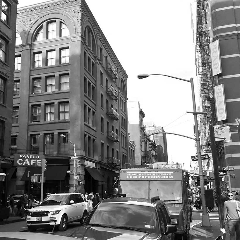
The SoHo/NoHo Neighborhood Plan (Plan), the area’s first major land use decision in 50 years, is poised to transform two iconic New York City neighborhoods. With the Plan, the City seeks to promote a mix of uses, primarily residential, and implement Mandatory Inclusionary Housing (MIH) in two of New York’s most established high-end, historic districts and along the edge of Chinatown. Creating affordable housing in high-opportunity historic districts such as Soho-Noho is a laudable goal that The Municipal Art Society (MAS) supports. In an equitable city, historic neighborhoods should be within reach of New Yorkers of all income levels as places to live. However, there remain red flags about whether the Plan will achieve its key objective of net-new affordable housing units. Instead, we find the proposal would spur high-end residential growth that will displace economically vulnerable long-time residents, make it harder to cultivate a wide spectrum of incomes, and introduce new development pressure without adequate protections for the area’s artistic community and historic resources.
The Plan, the final neighborhood rezoning under the de Blasio administration, comes on the heels of other neighborhood rezoning efforts, which have largely been concentrated in lower income communities of color. SoHo and NoHo, like all neighborhoods throughout the city, have the responsibility to address New York City’s housing crisis and advance fair housing. The City’s proposal, and attention to this area in New York City Housing Preservation and Development’s Where We Live Report, highlights the potential for transformation in SoHo-NoHo to bring new housing choices as well as lay the groundwork for diversifying other historic high opportunity neighborhoods throughout the city.
With potentially over 3,600 new residential units—the development equivalent of One World Trade Center1 —and almost 7,000 new residents anticipated if all development is fully realized, fundamental issues remain that the proposal has not adequately addressed and additional strategies that have not been integrated into it for it to be supported.2 There is simply too much at stake for the neighborhoods and other similar districts if the proposal is approved.
Download Testimony
Housing Affordability Plan
A successful housing affordability plan should be measured by how well it increases net affordability and housing choice; ensuring that the area is livable for people of all incomes with equitable access to stores, transit, and schools. The implementation of MIH as a one-size-fits-all approach of infusing affordable housing in neighborhood rezonings is not adequate in Soho-Noho, or other high-income neighborhoods. MIH alone is a blunt zoning tool that lacks sufficient nuance to effectively address the socioeconomic complexities of SoHo-NoHo. While the requirement of new affordable units triggered by MIH is an important tool, the rezoning lacks a thorough fair housing plan that would aim to increase net affordability and housing choice options.
To successfully infuse economic and racial diversity, we have urged the City to prioritize additional strategies to increase and guarantee affordable housing production, including site acquisition, developments, and investment through partnerships. In higher density portions of the rezoning area, particularly along Chinatown and the East Village, a small handful of sites could dramatically increase the production of income-restricted units while limiting some of the expansion of high-end, market-rate residential development both within and adjacent to the rezoning area. The project Final Environmental Impact Statement (FEIS) reveals a stark income disparity between new households in market rate units, earning over $230,000 a year, and the households in the affordable units required by MIH, earning around $57,000 a year. This also holds true for existing conditions, where average household incomes in portions of the East Village, Little Italy and Chinatown of the rezoning area range from $114,000 to $127,500, far below those in the rest of the rezoning area, which range from $204,300 to $388,500.3 The Plan falls short in facilitating a deeper and broader affordability across income scales to maximize housing choice within the neighborhood.
Affordable housing production and historic preservation protections can coexist and be mutually beneficial. Historic districts represent a form of community-based planning that creates a moment of community review to help manage change, not prevent it. A more comprehensive neighborhood planning approach could be achieved by scaling back the proposed zoning across the entirety of the project area. While we are pleased the City reduced the initial proposed density for commercial development and added the requirement that a certification from the City Planning Commission is needed to allow new retail uses over 25,000 square feet, these modifications are not nearly enough.
Historic Preservation
In the suite of de Blasio-era neighborhood rezoning proposals, Soho-Noho also stands out from a preservation perspective. Eighty percent of the rezoning area is within historic districts.4 These districts include over 800 buildings and 15 individually designated New York City landmarks. An alarming seventy-three historic buildings are expected to be demolished to make way for new development. Some of these buildings were constructed before 1820.5 The rezoning will also impact the S/NR-listed Bowery Historic District, the Samuel Tredwell Skidmore House (S/NR-listed, NYCL) and the Old Merchant’s House (NHL, S/NR-listed, NYCL, NYCL Interior) by allowing taller buildings on adjacent lots that will be out of scale with nearby historic districts and buildings. The FEIS concludes that there is no mechanism to avoid or fully mitigate these impacts at these sites because they are not protected under the New York City Landmarks Law.6
The FEIS asserts that development sites within the NYC landmark districts are protected under the Local Landmarks Law because redevelopment will be subject to Landmark Preservation Commission (LPC) review on a site-by-site basis. The FEIS also makes it clear that projected development sites not protected under the Landmark Law, those only within S/NR-listed districts, are subject to demolition and redevelopment without any additional review or oversight. Our research reveals that twelve buildings on eight of 26 projected development sites, concentrated along Chinatown and East Village, will be demolished. At least four buildings on these sites are considered contributing elements to the respective historic district.7
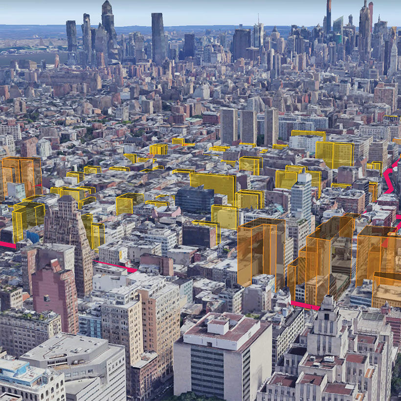
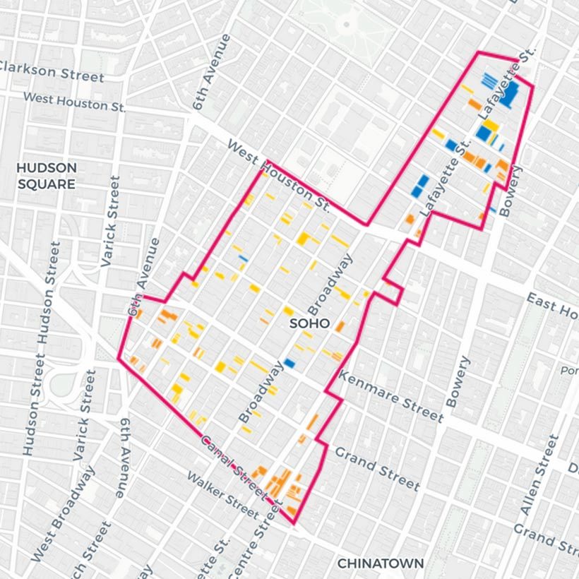
To bring this information into public view, MAS has developed an interactive web map that shows 3D extrusions of projected and potential development sites, including pedestrian perspectives at street level. The map also shows the development sites in relation to the historic districts and includes information on existing conditions and future development. We urge the City Council to utilize this resource in its decision making.
Expanded Role for LPC and SHPO
Throughout the CEQR and ULURP process, MAS has maintained that given the scale of redevelopment, the City needs to expand the role of LPC in the planning process and provide support for LPC, which would have the enormous task of reviewing potentially 76 applications in the rezoning area over the next few years. Additional staff funding could assist with additional reviews and evaluation of undesignated, yet contributing, resources for additional protection. We have also called for the City to include State Historic Preservation Office (SHPO) in the environmental review of proposed development outside of the landmark districts. Furthermore, MAS called for the City to work with LPC, SHPO and other key community stakeholders to identify the priority resources and develop tools, protections, and design guidelines that can more fully mitigate areas of interest that fall outside protections under the Local Landmarks Law. LPC should expedite review and designation of additional individual landmarks within the rezoning area. To encourage compatible design, LPC and DCP should publish a preferred material list and offer applicant support to encourage adaptive reuse of contributing structures. These recommendations were not adopted into the proposal. However, the City Council could convene a group to achieve those same ends.
Questions about Development Projections and Evaluation of Impacts
Potential Development Sites in Historic Districts
Throughout the CEQR process, MAS has questioned whether the full impact of the proposal would be assessed based on the Reasonable Worst Case Development Scenario (RWCDS). The RWCDS includes 26 projected development sites and 58 potential development sites. The number of potential development sites is of primary concern because they are all concentrated in the historic districts on sites occupied by existing buildings. Development on potential development sites could result in 1,758 dwelling units in addition to the 1,858 units on sites projected to be developed by 2031. Our extensive CEQR research has shown potential development sites and other sites within a rezoning area that are not identified often do get developed or enlarged through lot mergers and the transfer of development rights. The impacts of such development are not typically evaluated under CEQR, which is the case with this proposal. The most recent data (September 2020) show there are roughly 3 million square feet of existing development rights available within the Soho-Noho rezoning area: approximately 2.5 million square feet within the historic districts and 500,000 square feet beyond the historic district boundaries. The rezoning would result in more than 9 million square feet of additional density through available development rights, over 6 million square feet of which would be concentrated within the historic districts. However, LPC has only approved just over 1 million square feet in the last 10 years.
We have urged the City to study the incremental increase in density that has taken place under the purview of the LPC, and how such an exponential change could be borne on designated properties without wholesale destruction of these protected historic resources. This analysis was not provided in the FEIS and remains unaddressed. To remedy this, we recommend further limiting the amount of additional FAR within the historic districts, while still triggering MIH.
Conclusion
Over the past fifty years, Soho-Noho has been transformed from the place it was in 1971, when the City first rezoned the area in an effort to attract artists to occupy loft space in buildings previously occupied by long-departed manufacturing businesses. As it is poised to potentially transform again, Soho/Noho needs a plan that ensures that the historic character of these special neighborhoods is preserved, and current and new lower income residents can enjoy the benefits of living in two of the City’s iconic neighborhoods. MAS remains unconvinced the Plan before the City Council would achieve this goal. While MAS believes historic preservation protections and affordable housing opportunities can coexist, given the importance of this proposal, both in its potential to transform Soho-Noho and lay the groundwork for diversifying other historic high opportunity neighborhoods, we urge the City Council to deny it.
Notes
- Total residential development expected under the Plan is 3,510,425 million gross square feet. Total floor area of One World Trade Center is 3,501,274 square feet.
- The Soho/Noho Neighborhood Plan Final Environmental Impact Statement (FEIS) identifies 26 projected development sites totaling 1,858 new dwelling units and 3,512 new residents. In addition, the Plan includes 58 potential development sites totaling 1,758 dwelling units, which would add 3,323 new residents.
- FEIS Table 3-3 Household Income Characteristics (2006-2010, 2014-2018 ACS).
- The rezoning area includes NYC-designated landmark districts Soho-Cast Iron Historic District and Extension, Noho Historic District and Extension, Noho East Historic District, and parts of the Sullivan Thompson Historic District. The rezoning area also includes portions of three State and National Register-listed Districts, Soho Historic District, Bowery Historic District, and the Chinatown and Little Italy Historic District.
- According to the FEIS, the three-story building at 143 Spring Street (Potential Development Site RR) was constructed in 1818 and the building at 146 Spring Street (Potential Development Site BBB) was built in 1819.
- Soho-Noho Neighborhood Plan Draft Environmental Impact Statement, p. 23-4.
- These include 348, 350, 352, and 358 Bowery.

Become a member to enjoy discounts to events and tours.
Learn about membershipRelated Initiatives
Related News + Reports