Two Bridges Proposal Would Permanently Change the Neighborhood
Testimony to the Mayor’s Office of Environmental Coordination
The Municipal Art Society of New York (MAS) has supported sound planning and effective community engagement in New York City for 125 years. We have supported the community planning processes that have taken place in the Two Bridges neighborhood, an area that faces myriad dire consequences from proposed redevelopment in the Two Bridges Urban Renewal Area (URA).
The current Two Bridges Large-Scale Residential Development (LSRD) Proposal, now under consideration by the City Planning Commission (CPC), would result in over 2.5 million gross square feet of new development, including over 2,500 new dwelling units within three high-rise buildings. The proposal is expected to bring in almost 6,000 new residents. It is clear the development will permanently change the Two Bridges neighborhood.
Download Testimony-
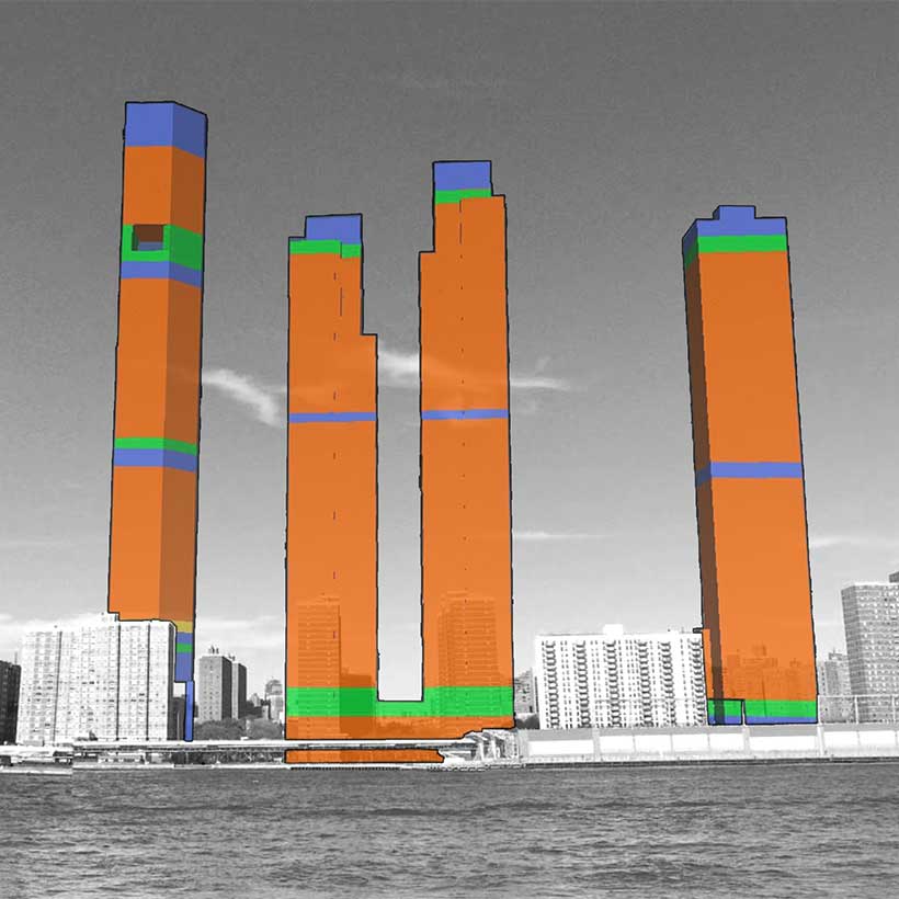
 Photosimulation looking from the East River showing proposed developments at Two Bridges. Based on DEIS CEQR No. 17DCP148M ©Google Street Image. Modified by MAS.photo 1 of 2
 -
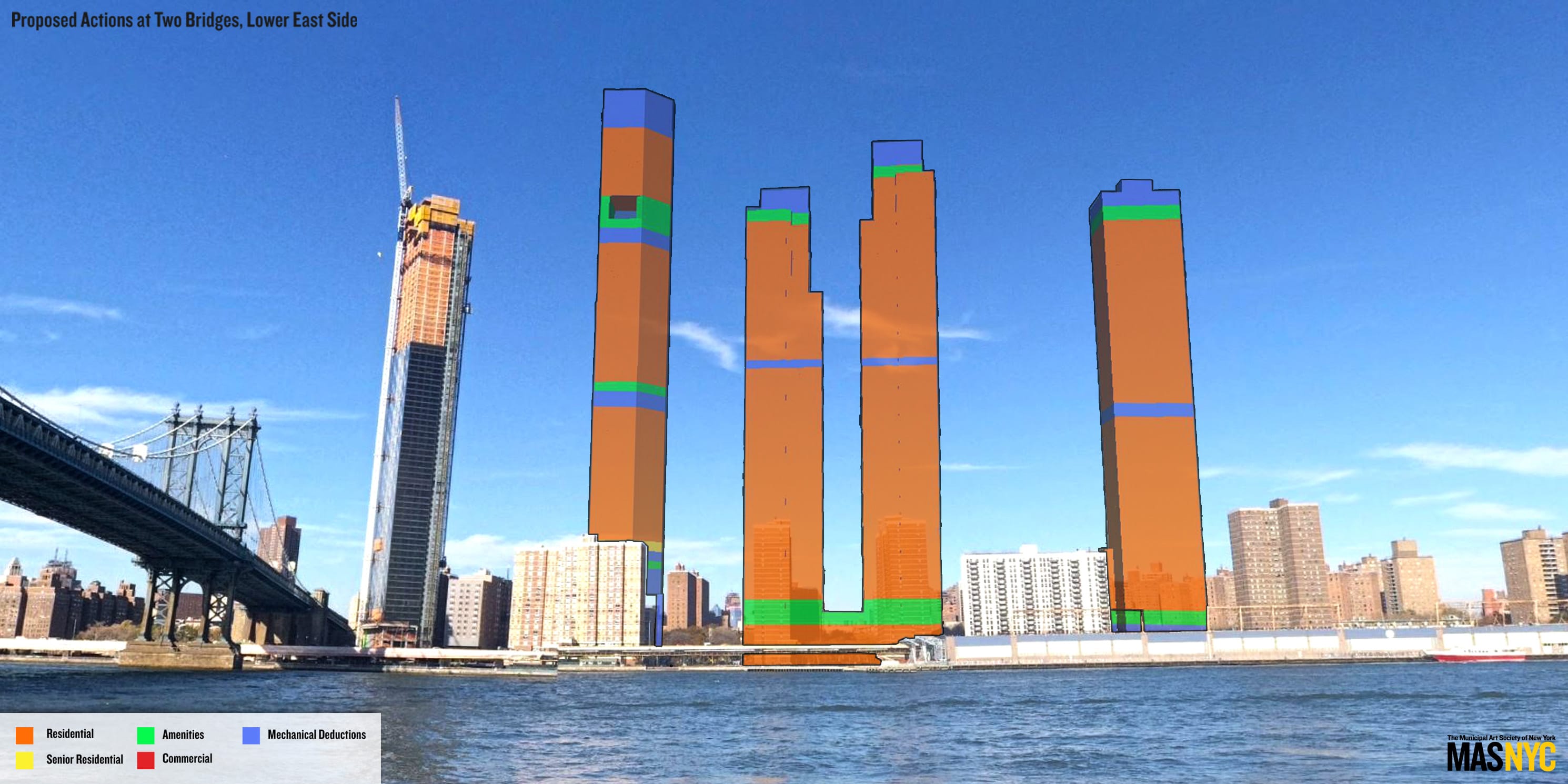
 Renderings of proposed developments at Two Bridges showing neighboring buildings to the west. Based on DEIS CEQR No. 17DCP148M ©New York City Department of Information Technology & Telecommunications. Modified by MAS.photo 2 of 2
Conditions for Minor Modification
We find the proposed developments within the Two Bridges LSRD do not comply with the New York City Zoning Resolution (ZR) regulations described in Article VII Chapter 8 due to the many unmitigated adverse impacts that will result. According to ZR 78-313, requirements for authorizations or “minor modifications” must meet a number of conditions as a prerequisite for modification. The conditions applicable to the project are described as follows.
Pursuant to 78-313 (a), modifications will aid in achieving the general purposes and intent of the LSRD which includes the promotion and facilitation of better site planning and community planning. The modifications will also enable open space to be arranged to best serve the active and passive recreation needs of residents and the City as a whole. However, to this point, no demonstrative community planning has been done by the City or the developers. And as discussed under “Open Space” and “Shadows,” the modifications will not best serve the needs of area residents because they will lead to development that will have adverse effects on open space in the project area.
Pursuant to 78-313 (b), the distribution of floor area and dwelling units must benefit residents of the LSRD and must not unduly increase the bulk of buildings, density of population, or intensity of use to the detriment of residents in that block or nearby blocks. However, based on the DEIS, the proposed developments will result in unmitigated adverse impacts on socioeconomic conditions, community facilities, open space, shadows, transportation, parking, and construction.
Pursuant to 78-313 (d), the distribution and location of floor area must not adversely affect access to light and air outside the LSRD or create traffic congestion. However, as described in the shadows and transportation sections below, the authorizations would allow the construction of development that would significantly limit light and air in the neighborhood and cause major impacts on local traffic congestion and the availability of parking.
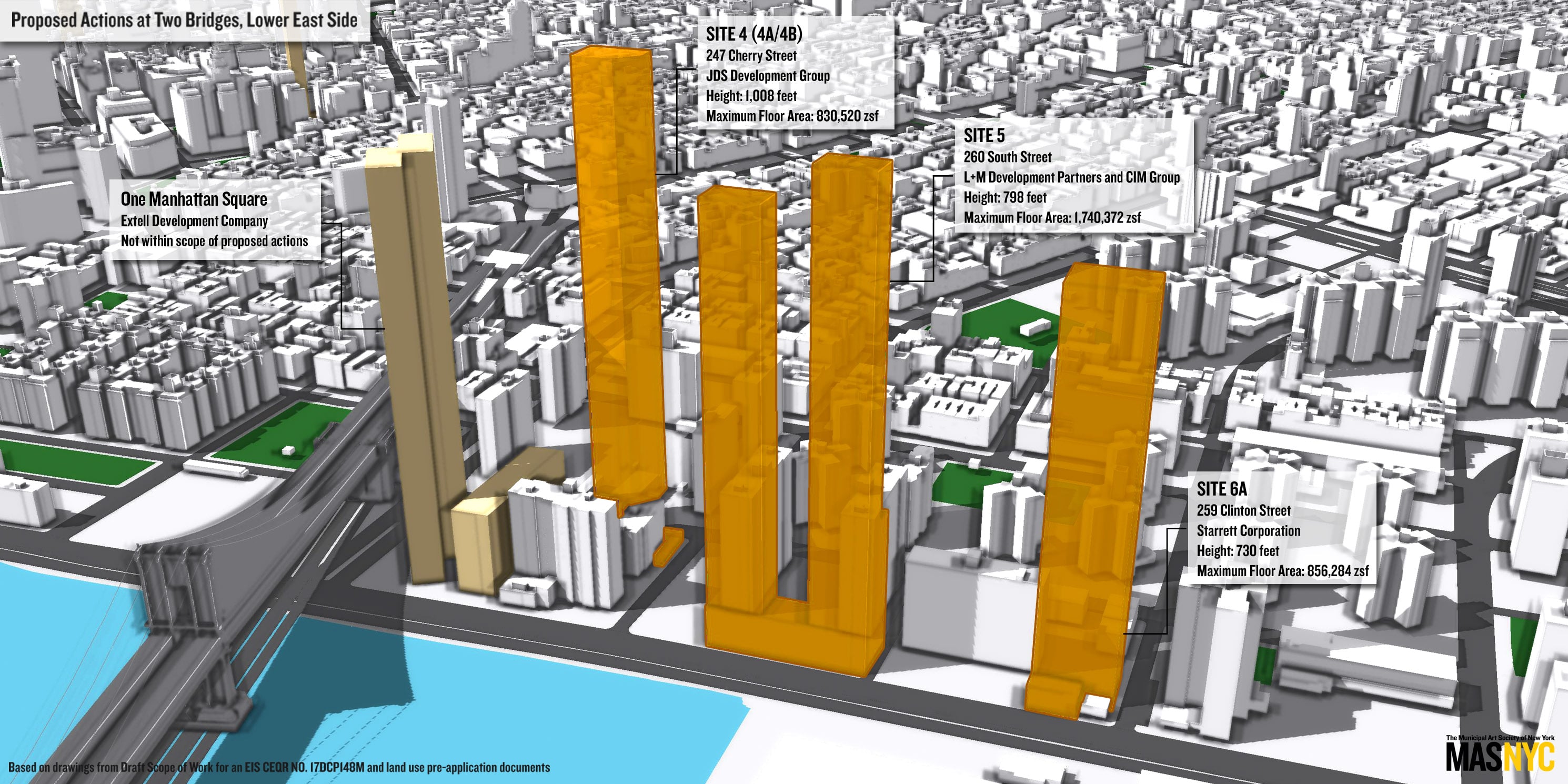
Pursuant to 78-313 (g), the modification of height and setback must not impair the essential character of the surrounding area and must not have adverse effects upon access to light, air and privacy of adjacent properties. However, the proposed developments would substantially change the essential character of the neighborhood by adding approximately 6,000 new residents through the construction of over 1.5 million gross square feet of residential development within three massive towers that will respectively be 1,008, 798, and 730 feet tall. Furthermore, the proposed development at Site 4A/4B would cantilever over the existing Two Bridges Helen Hayes Senior Residences at 80 Rutgers Slip. As such, the proposed developments would clearly infringe upon the light and air of area residents.
Review Process
The modifications to the LSRD site plan that facilitate the proposed development are not “minor” as asserted by the City, and instead, warrant a Special Permit, which would ensure that the project would be subject to the Uniform Land Use Review Procedure (ULURP). Such a review would give the public an opportunity to provide valuable input and allow City Council members to represent the interests of their constituents.
Without the benefit of ULURP, the public’s only opportunity to comment on the project is through the City Environmental Quality Review (CEQR) process. However, the CEQR process alone does not provide the opportunity for the robust public discourse a project of this magnitude requires.
The Department of City Planning (DCP) released the project DEIS on June 22, 2018, which started a 60-day period for Manhattan Community Board 3 to review the proposal, CEQR documents, and issue a resolution. However, the DEIS does not provide sufficient, specific mitigation measures to address the many adverse impacts that are expected to result from the development. Without ULURP, the public has no opportunity to comment on any subsequent proposed mitigation measures, assuming they are disclosed in the Final Environmental Impact Statement (FEIS).
Socioeconomic Conditions
MAS has a number of concerns about how the proposed development would affect socioeconomic conditions in the Two Bridges neighborhood. The DEIS states that 88 percent of residents in the area live in buildings protected by rent control, rent stabilization, or other government controls. However, we question how well protected these residents actually are. We have found in many areas of the city, especially low-income neighborhoods that are being rezoned, tenants in rent-stabilized units are often susceptible to harassment and eviction by landlords pressured by a rising housing market.
The DEIS concludes that the project would not significantly lead to indirect business displacement. However, the anticipated change in the demographics of the area could have a significant impact on local retail because new residents in the market-rate dwelling units will have significantly higher incomes than current residents in the study area, and thus will have much greater disposable incomes and different retail preferences. If retail displacement occurs, current residents could likely be priced out of future retail opportunities in the area.
Community Facilities
The proposed development would have adverse impacts on public school utilization in the project area. In the development scenario without housing units reserved for seniors, elementary school utilization in Community School District 1, Subdistrict 1 would increase from 90 percent to 111.3 percent capacity. Utilization in Community School District 1, as a whole, would increase to 100 percent.
Publicly funded childcare facilities face similar impacts with regard to utilization. According to the DEIS, publicly funded childcare facilities in the study area are currently operating at 87 percent capacity, with 160 available slots. With the proposed development, the utilization would increase to 110 percent, resulting in a deficit of 119 daycare slots. Despite these impacts, the DEIS does not propose any specific mitigation measures to address capacity issues for either public schools or publicly funded childcare facilities. Specific mitigation measures must be addressed in the FEIS.
Open Space
The proposed development would overburden existing open space and offers no new open space to address the demand expected from the approximately 6,000 new residents. According to the DEIS, the proposed development would decrease the open space ratio–which is a measure of acres of open space per 1,000 residents–by over 7 percent. Which is significant in a neighborhood that is as underserved by open space as Two Bridges.
Despite the impacts, the DEIS offers no acceptable mitigation measures. According to the DEIS, one of the primary proposals considered is expanding and enhancing private open space in the area. However, private open space is typically not publicly accessible. Therefore, we urge the City to explore opportunities in the project area to development new public open space. If new public open space is not feasible, we suggest legally binding agreements be put in place to ensure that private open space is made publicly accessible. Furthermore, any new space, public or private, should be safeguarded to the extent practicable from the shadows cast by the new developments. See additional comments below regarding shadows.
Shadows
The proposed development would cause adverse shadow impacts on Cherry Clinton Playground and Lillian D. Wald Playground. However, shadow impacts on NYCHA campuses and privately owned open space, including Rutgers Slip were not evaluated in the DEIS. Despite the significant impacts, the DEIS does not propose any mitigation measures to reduce shadows. The open space impacts raise critical questions about whether the proposed actions truly facilitate the better use of open space, the preservation of natural features, and a general protection of health, safety and general welfare as promoted by the LSRD regulations. The DEIS was deficient in not identifying specific mitigation measures regarding shadows. Therefore, we expect specific mitigation measures (e.g., building design modifications) will be outlined in the FEIS.
Urban Design and Visual Resources
MAS has modeled and assessed the proposed developments in the context of urban design in the Two Bridges neighborhood. The DEIS evaluation of the proposed development’s impacts on urban design and visual resources fails to recognize the scale and proportion of the proposed projects. With towers ranging between 730 and over 1,000 feet tall, and additional bulk that would bring over 2.5 million square feet of floor area, the magnitude of the developments cannot be overstated. The developments will clearly affect existing urban design and the pedestrian experience in the neighborhood.
The tallest proposed development (Site 4A/4B) will be over 15 times taller than the median height of existing buildings within the primary area (including One Manhattan Square). There are 370 buildings within the primary study area (quarter-mile distance). The mean height of these buildings is 67 feet, hundreds of feet shorter than the proposed projects. Within the secondary study area there are 1,414 buildings, these have a mean height of just approximately 62 feet. It is clear that the proposed developments will be out of context with existing buildings in the primary and secondary areas. Furthermore, the DEIS does not evaluate potential impacts of the proposed development on views of the Manhattan Bridge.
Natural Resources
The DEIS describes how nighttime migratory bird collisions are more likely to occur on buildings above 656 feet. Despite the fact that the proposed buildings are between 730 and 1,008 feet tall, the DEIS downplays the impacts of the proposed development on bird collisions. Furthermore, the DEIS describes methods (patterned or fritted glass) that could reduce bird collisions, but does not indicate that any of these methods will be implemented nor how potential bird collisions would be reduced by the proposed design or materials used. Remarkably, the DEIS concludes there will be no significant impacts.
Water and Sewer Infrastructure
The proposed development will have impacts on water and sewer infrastructure. The DEIS does disclose impacts on the stormwater infrastructure during heavy rain events. According to the DEIS, the volume of sewage sent to combined sewer system (CSS) NCM-063 will more than double from existing conditions, up to 480,000 gallons. Including the runoff volume of a 2.5-inch storm event with a duration of 19.5 hours, the total volume of wastewater sent to CSS NCM-063 is expected to reach 840,000 gallons, a 50 percent increase over existing conditions. And yet, no mitigation measures are identified in the DEIS.
Transportation
Traffic
The Two Bridges area is already afflicted with traffic congestion from the Brooklyn and Manhattan Bridges and FDR Drive. According to the DEIS, the proposed projects would result in additional significant adverse traffic impacts at six intersections during the weekday AM peak hour, five intersections during the weekday midday peak hour, and 10 intersections during the weekday PM peak hour. According to Table 21-1 of the DEIS, a maximum of 10 intersections and 18 lane groups will experience significant adverse impacts. The weekday PM Peak Hour will be most affected. For mitigation of these impacts, the DEIS does not go beyond identifying the implementation of standard traffic mitigation measures such as signal timing and lane restriping. Equally concerning is that the mitigation measures have yet to be approved by the DOT and may in fact be deemed infeasible, which would leave the impacts unmitigated. This is unacceptable for this neighborhood.
Transit
The nearly 6,000 additional residents expected under the proposal would place substantial demand on local subway infrastructure. According to the DEIS, the nearest subway station, East Broadway-Rutgers Street Station (F), has an average weekday ridership of 14,365. The DEIS states that the influx of new residents would not significantly impact the subway line service, but will affect station access and pedestrian circulation during AM and PM peak hours. At best, this is assessment is an underestimation. At worst, there will be a degradation in service not only at the East-Broadway Station, but also on this segment of the F line during peak hours.
Parking
MAS fears that the proposed action will result in a crippling shortage of parking in the area. Within one-half-mile of the project area, public parking utilization will increase to more than 112 percent of off-street parking facility capacity in the area. This represents a parking shortfall of more than 1,500 spaces during weekday peak periods. Furthermore, during the anticipated 30 to 36-month construction period, the proposed development is expected to generate a need for 355 additional spaces based on construction worker demand.
The DEIS states that excess parking demands during the weekday peak periods would need to be accommodated by on-street parking or off-street parking beyond a one-half-mile walk from the project sites. According to the CEQR Technical Manual, a parking shortfall resulting from a project in Manhattan does not constitute a significant adverse impact due to the availability of alternative modes of transportation. However, as stated in the Transit section, adverse impacts on access and pedestrian circulation are anticipated to occur at the East Broadway-Rutgers Street Station during AM and PM peak hours. Therefore, this conclusion is faulty.
Conclusion
The proposed development under the Minor Modification to the Two Bridges LSRD will have serious, long-term, adverse consequences on the Two Bridges community. This neighborhood has been largely left out the planning process for a development that will have far-reaching ramifications. We urge the City to address the concerns we have raised and more importantly, to foster effective input to arrive at a development plan that works best for the Two Bridges community.
Thank you for the opportunity to comment on this critical proposal.
Help us continue our planning advocacy on behalf of New York City.
DonateRelated News + Reports