Franklin Avenue Towers Threaten Brooklyn Botanic Garden & Neighborhood Affordability
Testimony to the New York City Department of City Planning
The Municipal Art Society of New York (MAS) recognizes the need for affordable housing in the Crown Heights neighborhood of Brooklyn. The current zoning for the development area in question was put in place as a compromise in 1991 to protect the Brooklyn Botanic Garden. Under these circumstances, we question the rationale for a 1.4 million gross square foot development and the mechanisms used to increase the height and density of the proposed towers. We have major concerns about the shadows that would be cast on Jackie Robinson Playground and the nearby conservatories, greenhouses, and nurseries at the Brooklyn Botanic Garden, as well as the lack of publicly accessible open space being provided.
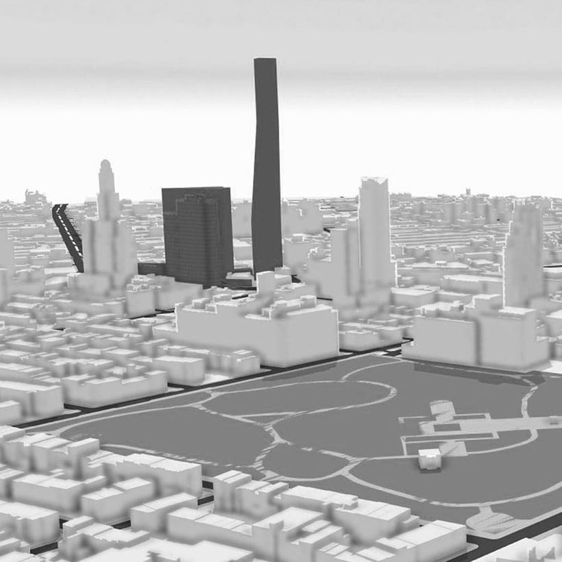
According to the Draft Scope of Work (DSOW), the Applicant seeks to rezone four lots and three partial lots from R6A and R8A to an R9D district and increase the residential FAR to 10.0. The rezoning would allow the development of two 39-story (421 and 424 feet tall, respectively), mixed-use buildings. The residential component includes 1,578 housing units, of which 789 would be affordable under Mandatory Inclusionary Housing (MIH). The proposal also calls for an incremental decrease of 79 parking spaces and 50,258 square feet (sf) of new open space, of which only 17,959 sf would be publicly accessible. Construction is expected to occur in two consecutive phases between October 2019 and April 2024. In total, the project will bring 4,134 new residents to the area.
Therefore, MAS requests the following items be included in the Final Scope of Work and evaluated in the Draft Environmental Impact Statement (DEIS).
Download Testimony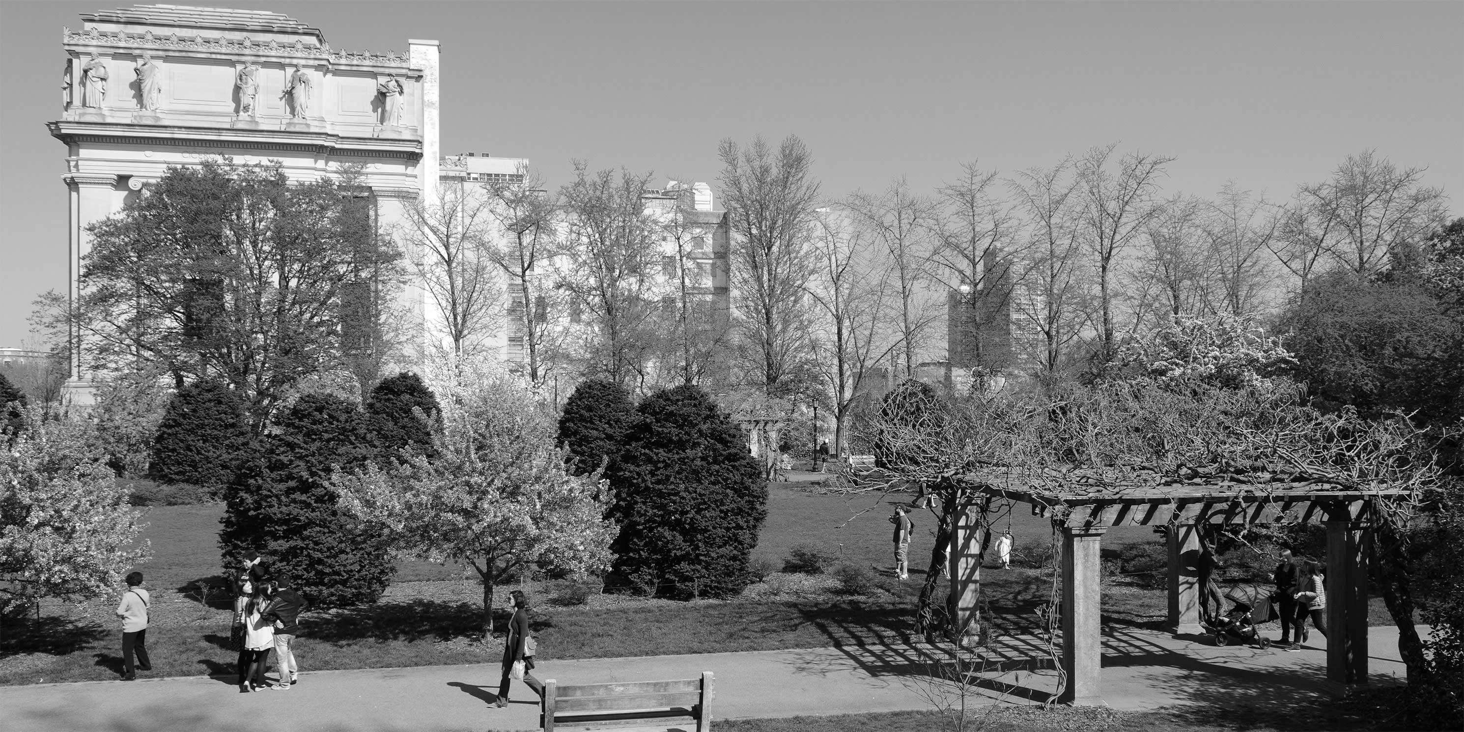
Project Description
The requested R9D zoning designation would allow an FAR of up to 10.0 under MIH. However, the Applicant is choosing to utilize only 9.7 of the available FAR, which would be recorded under a Restrictive Declaration (RD). To clarify this choice, the DEIS must include an explanation for why the Applicant is not using the remaining 0.3 FAR for additional affordable housing–which is a stated primary objective of the project–and include a summary of the conditions of the RD, which will govern the site.
As previously stated, the project would be developed in two phases, with all of the community facility space and 384 affordable units scheduled for construction in the second phase. Because information is not provided in the DSOW, we request that the DEIS explain the reasoning for phasing construction and in particular the development of community facilities and affordable housing units in the second phase.
Land Use, Zoning, and Public Policy
The project would require a Large-Scale General Development (LSGD) Special Permit, and zoning waivers to reduce minimum lot coverage from 33 percent to 11.4 percent, or a 65 percent reduction. The Applicant is also seeking to waive tower coverage regulations that require the building’s top four floors to be set back 50 to 80 percent above 165 feet in height. With the waiver, the developer would be able to build with 100 percent tower coverage with no setbacks on the uppermost floors. According to the DSOW, these modifications would “promote better site planning and urban design on the Development Site” and “allow slender, uniform towers.”
We are unconvinced of this rationale. The DSOW and other project information fail to demonstrate how the waivers actually improve site planning and urban design. Nor is it clear how adding bulk and eliminating setbacks on the top floors would result in more slender tower design. Instead, we believe the Special Permit and subsequent zoning waivers are part of a strategy to facilitate taller towers with larger (and more valuable) upper floor area than would otherwise be allowed. Therefore, MAS requests a clear and thorough explanation as to how the Special Permit and waivers would enhance site planning and design on the Development Site.
Socioeconomic Conditions
At the March 12, 2019 public scoping meeting, the project planning consultant stated that 40 percent of the affordable units would accommodate families at or below 50 percent Area Median Income (AMI) under MIH. However, this figure is not included in the DSOW. Rather, the DSOW states that the lowest affordability level for the project will be 80 percent AMI ($75,120 for a family of three). This is significantly higher than the $53,401 median household income within a half-mile radius of the project site.1
Based on this new information, the DEIS must provide a specific breakdown of planned affordable housing in percentage terms and by AMI level. The DEIS must also affirm that 40 percent of the affordable units would accommodate families at or below 50 percent AMI, if this is indeed true. If not true, MAS requests that a deeper level of affordability be evaluated in the DEIS than the 80, 100, and 120 percent AMI levels stated in the DSOW. We also request that the DEIS provide details on the specific source and magnitude of funding for the portion of affordable housing that requires public financing.
Open Space
As mentioned previously, the proposed project would create approximately 50,258 sf of open space, of which only 17,959 sf, or 36 percent, would be accessible to the public. Operating hours of the publicly accessible space are expected to be limited from dawn to dusk. Given the massive scale of the project, the amount of new residents, and the size of the Development Site (2.76 acres), MAS finds the proposed open space underwhelming. We also question why this space would have restricted operating hours, with no specific amenities known at this time, and no actual commitment to build the space. Therefore, we strongly recommend that more open space be provided, and that it be publically accessible 24 hours day. We request that the DEIS include a detailed site plan showing the proposed layout and amenities of the open space. MAS also suggests examining using the area made available by waiving the 282 parking spaces for at least an additional acre of public open space.
The DSOW also notes that there are several large open spaces within the secondary study area, including the Prospect Park Zoo and a majority of the Brooklyn Botanic Garden. However, both of these amenities require paid admission and should be excluded from DEIS calculations of publicly accessible open space.
Shadows
It is clear that the project will result in shadow impacts on the nearby Brooklyn Botanic Garden. MAS conducted preliminary shadow modeling using CEQR Technical Manual criteria to identify representative days for analysis. Our study shows that project-related shadows would affect the Brooklyn Botanic Garden during the early morning hours in March, June, August, and December, a potentially significant impact depending on the sun-dependency and growing seasons of the Garden’s plant species.
Specifically, incremental project-related shadows would fall on the Garden between:
- 8:22 and 9:40am in March
- 6:58 and 9:50am in June
- 7:33 and 8:55am in August
- 9:13 and 10:05am in December
The greatest incremental shadow impact would occur on the Herb Garden. Currently experiencing little shadow, it would be partially or fully covered in early morning shadow for the majority of the year with the Proposed Project. Other gardens that currently experience little to no shadow but which would be mostly or fully covered in early morning shadow include the Rock Garden (in spring), Discovery Garden (in summer), and Cherry Esplanade, Cranford Rose Garden, and Native Flora Garden (in winter). Noticeably longer morning shadow durations would also occur on the Plant Family Collection, Shelby White and Leon Levy Water Garden, and Steinhardt Conservatory for most of the year.
Jackie Robinson Playground, located directly east of the project site, contains basketball and handball courts, fitness equipment, and play structures for local children and adults. Building-related shadows would cover much of the playground during the early and mid-morning hours in March, June, August, and December. Currently, there is little to no afternoon shadow. Should the Proposed Development be built, however, the playground would be cast in partial shadow from about 1:30pm, and full shadow from about 3:30pm until sunset during these evaluation months. This leaves only a few late morning and early afternoon hours for local residents to enjoy the playground in unobstructed sunlight.
To properly address these adverse effects, we expect that the City and Applicant will meet with Brooklyn Botanic Garden officials to discuss ways to eliminate and/or mitigate potential shadows. Furthermore, the DEIS must describe in detail the specific shadow impacts on each affected plant species within the Brooklyn Botanic Garden and include a description of appropriate mitigation measures on Jackie Robinson Playground. All coordination efforts between the Brooklyn Botanic Garden and the Applicant/City should be described in the DEIS.
Historic and Cultural Resources
According to the DSOW, the Landmarks Preservation Commission (LPC) confirmed that the historic buildings on lots 41 and 46 are eligible for the New York State and National Register of Historic Places. All correspondence with LPC and SHPO should be provided for these and other lots within the proposed rezoning area.
Energy
We request that the energy evaluation go beyond merely disclosing the projected energy demand of the Proposed Project and include information about sustainable design practices to be implemented during construction and operation. For a project of this magnitude, LEED™ building standards or equivalent should be considered. The DEIS should also evaluate the possibility of a more comprehensive Optimal Sustainable Development Scenario, a design alternative that demonstrates energy and water use savings with the application of sustainable practices for construction and operation.
Transportation
According to the DSOW, the development would generate more than 50 additional vehicular trips in the weekday AM, midday, and PM peak hours, as well as the Saturday midday peak hour, thereby necessitating a travel demand forecast. However, only eight intersections are identified for further analysis, and none are located east of the rezoning area. MAS requests a broader traffic analysis that extends at least 0.25-miles from the project site boundary, or a detailed explanation and the assumptions as to why additional intersections were not identified for further analysis.
Construction
Given the scale of the project and the longer, phased construction timeframe, the DSOW should include a detailed evaluation of work-related traffic, air quality, and noise impacts – including those affecting the immediately adjacent Jackie Robinson Playground, P.S. 375 Jackie Robinson School, and Ebbetts Field Middle School.
Mitigation
The DEIS should include specific mitigation measures approved by the City agency responsible for implementing them. This would provide the public with the opportunity to review and comment before the issuance of the Final Environmental Impact Statement.
Conclusion
MAS recognizes the project contributes towards the expansion of affordable housing in Crown Heights, Brooklyn. However, we cannot support the development until major concerns about its scale, site planning rationale, AMI levels, open space, shadows, and other significant factors are fully addressed.
Notes
- 2012-2016 American Community Survey Data from the New York City Population FactFinder
Help us continue our planning advocacy on behalf of New York City.
DonateRelated Initiatives
Related News + Reports