Cumulative Impacts of Anable Basin Rezoning Must Be Studied
MAS Comments on the Draft Scope of Work for Anable Basin's Environmental Impact Statement
The Municipal Art Society of New York (MAS) believes the Anable Basin waterfront in Long Island City may be an appropriate setting for well-planned and coordinated redevelopment. From an economic development perspective, we also find the potential establishment of an employment hub that would leverage Long Island City’s proximity to Roosevelt Island’s Cornell Tech campus worth exploring.
However, we are extremely concerned about two major issues with this rezoning proposal. One is the magnitude of the development proposed by the applicant Plaxall Plastic. The second is the significant cumulative environmental impacts that are very likely to occur with the rezoning and other large-scale development and rezoning proposals in the area, which raises the issue of segmentation of the environmental review process.
Therefore, we call on the City to conduct a coordinated review of the cumulative environmental impacts of the Anable Basin Rezoning, the New York City Economic Development Corporation’s (EDC) Long Island City (LIC) Waterfront Project, and the Department of City Planning’s (DCP) LIC Core rezoning. The full array of potential effects and mitigation measures must be accurately identified, measured, and evaluated.
Download Testimony-
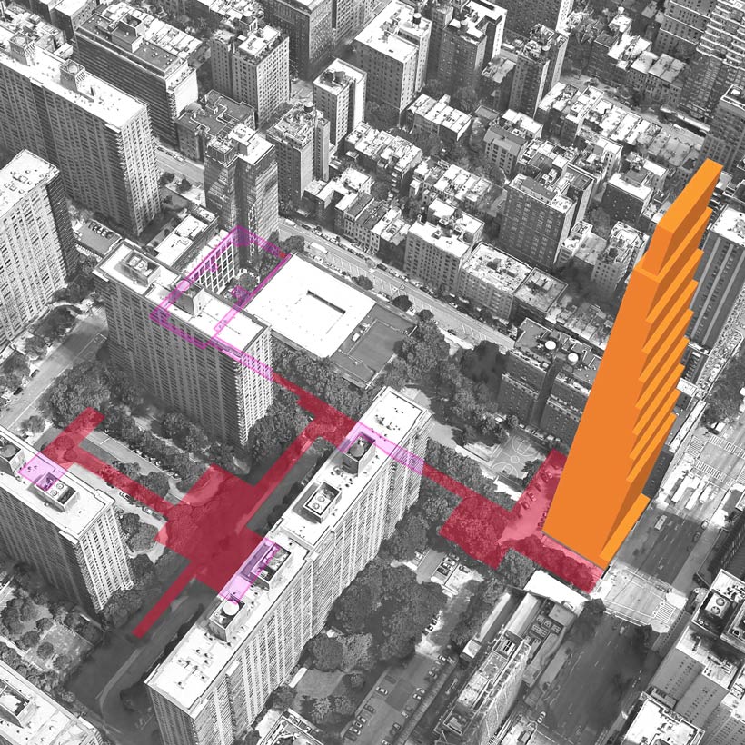
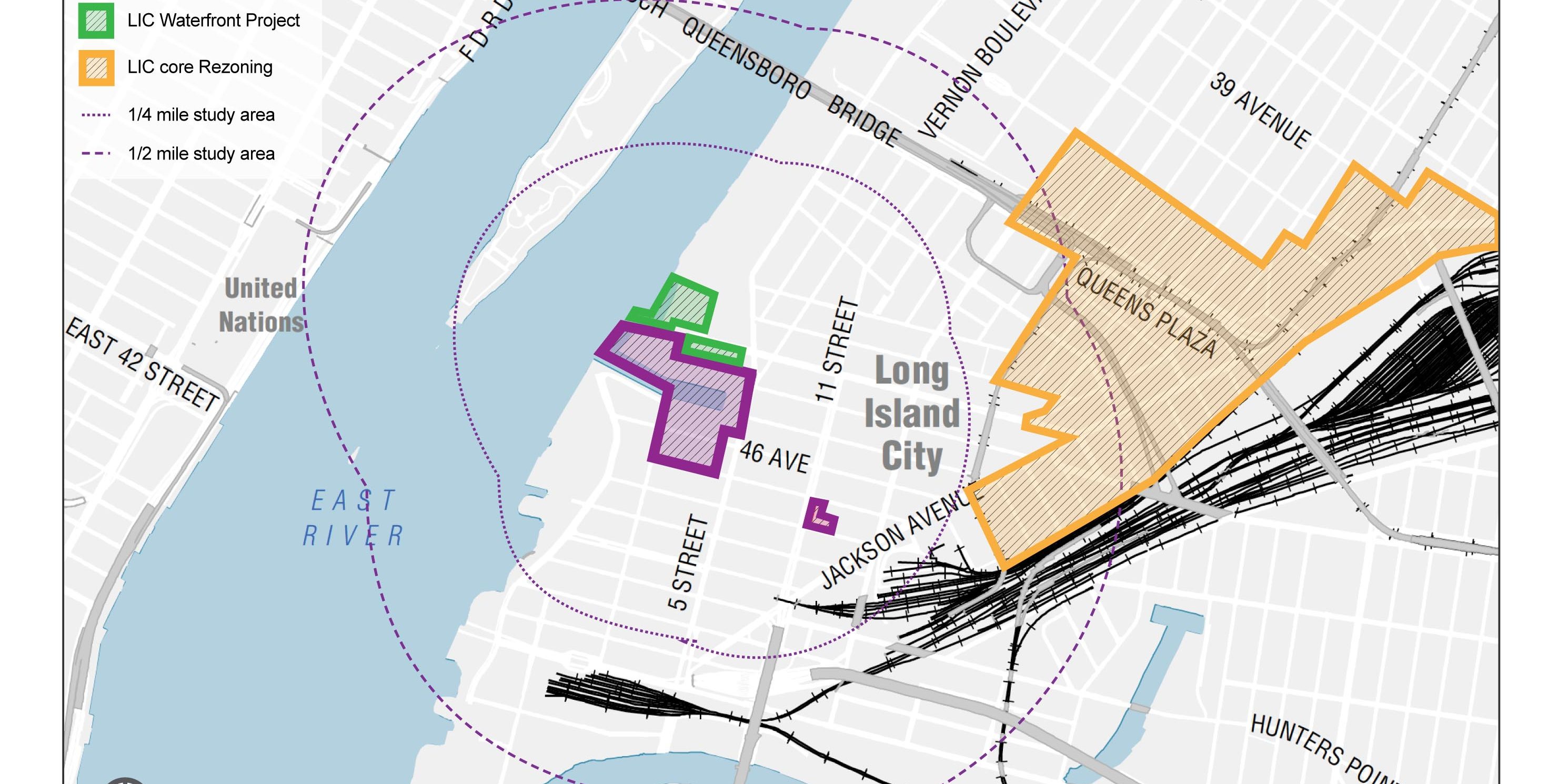 Figure 1: Potential segmentation from the rezoning.photo 1 of 8
 -
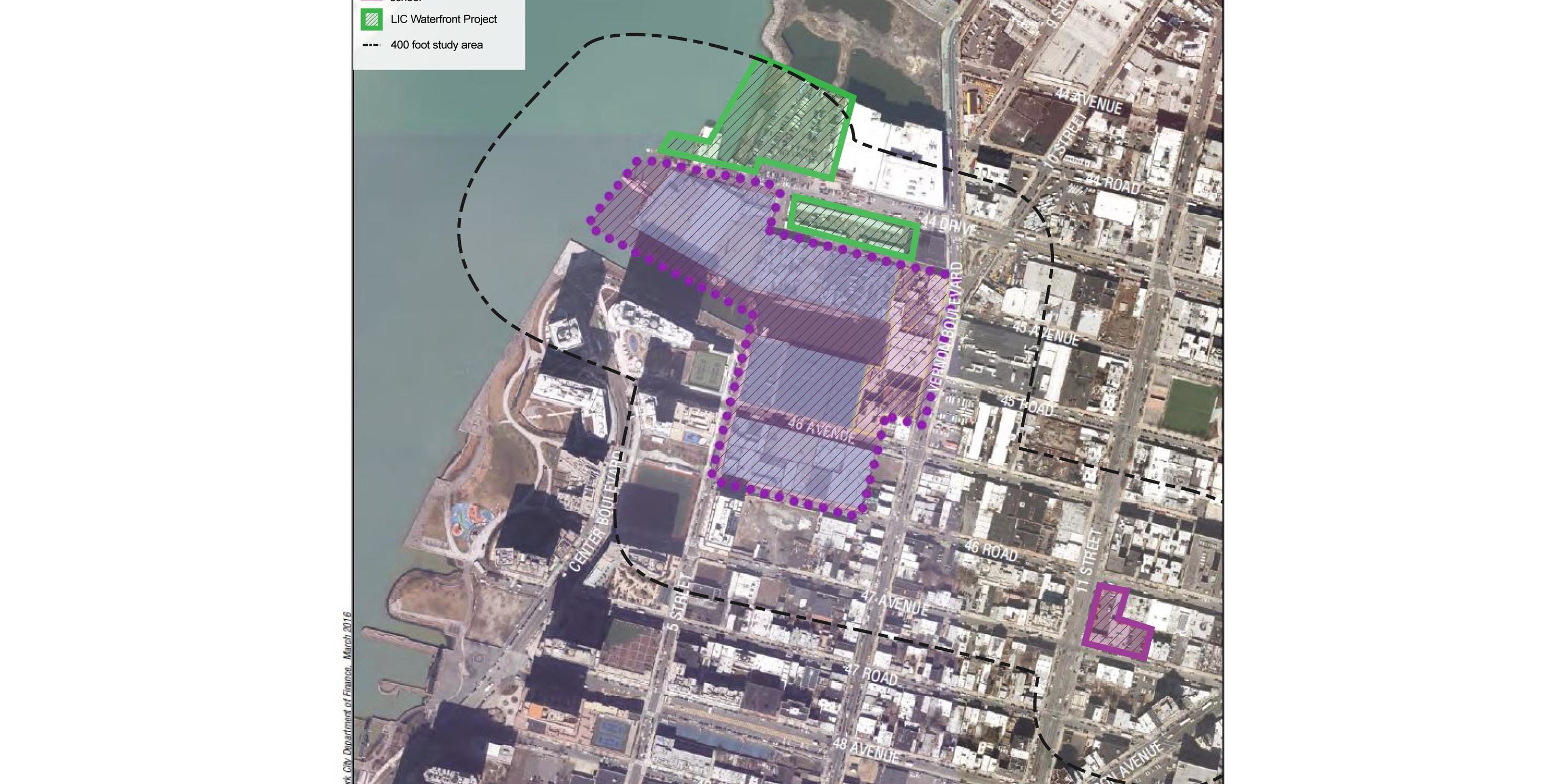 Figure 2: Potential segmentation from the rezoning.photo 2 of 8
 -
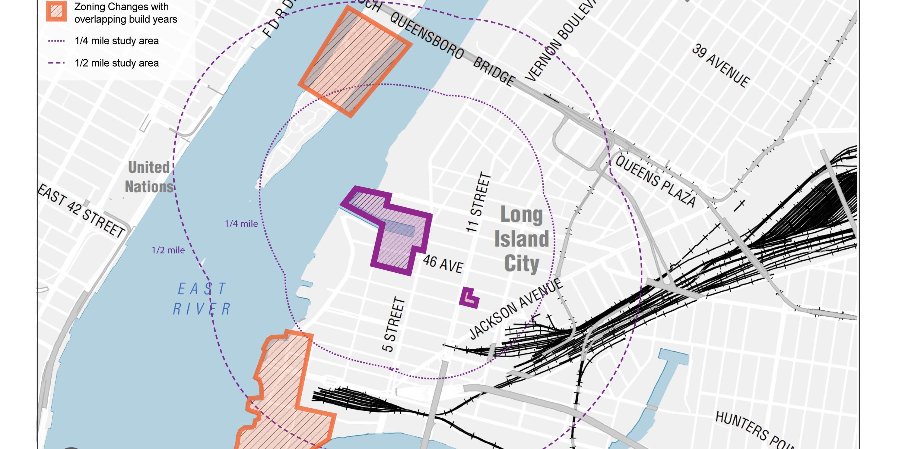 Figure 3: Cumulative impacts from the rezoning.photo 3 of 8
 -
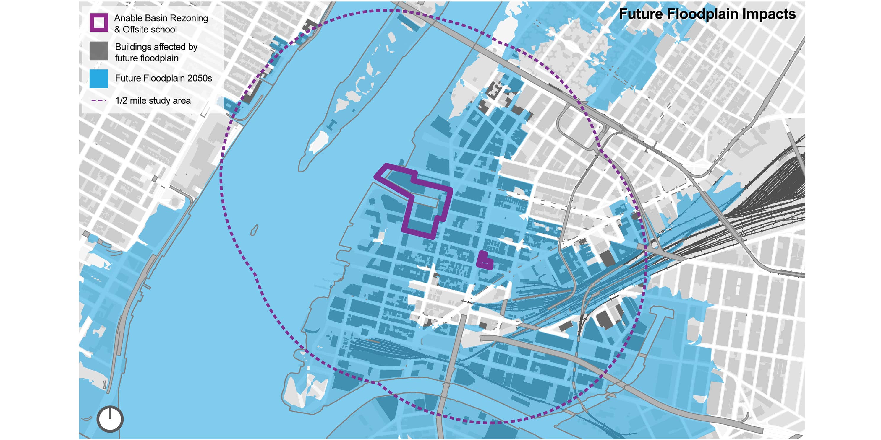 Figure 4: According to the New York Panel on Climate Change (NPCC) 75% of the buildings within half a mile of the project area (912 out of 1,206 existing buildings) will be affected by the 2050 – 100 year flood zonephoto 4 of 8
 -
 Figure 5: Incremental shadows casted by Anable Basin RWCDS I and LIC Waterfront Project on the East River, Waterfront Access Areas, and Gordon Trianglephoto 5 of 8
 -
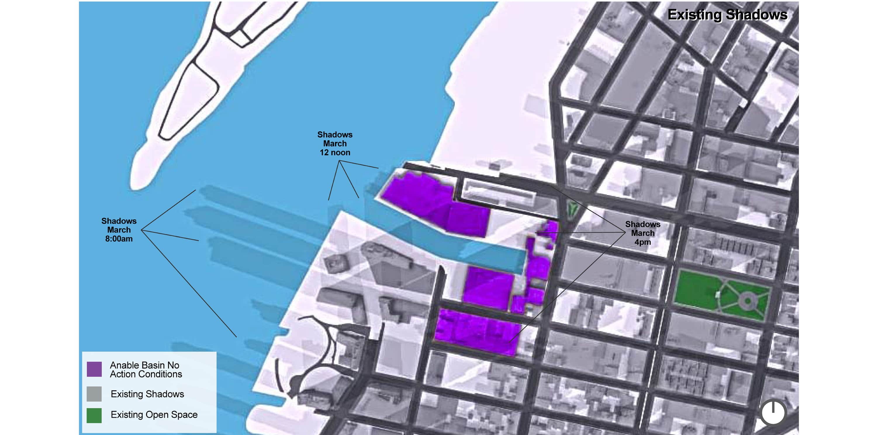 Figure 6: Existing shadows on the East River, Waterfront Access Areas, and Gordon Trianglephoto 6 of 8
 -
 Figure 7: 3D Interactive model based on RWCDS I and estimated massing for LIC Waterfront Project. Follow this link to view on any browser.photo 7 of 8
 -
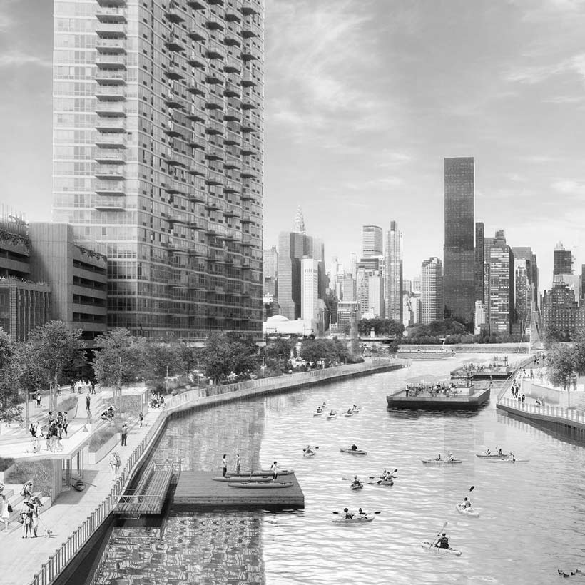
 Rendering of Anable Basin after redevelopment.photo 8 of 8
Background
Plaxall Plastics is proposing a series of zoning actions (Proposed Actions) that would create a 15-acre Special Anable Basin Mixed-Used District, including 13 major development sites. The development proposes five primarily residential towers, ranging in height between 500 and 700 feet, a public waterfront esplanade, and an off-site public school.
According to one of the two Reasonable Worst-Case Development Scenarios (RWCDS) described in the project DSOW, the rezoning would result in a maximum of 13,487 new residents, 4,995 additional dwelling units (25 percent of which would be affordable), 122,651 square feet (sf) of retail, 254,520 sf of light industrial, and 134,695 sf of open space, for a total over 5.7 million sf of new development.
Comments on Draft Scope of Work
Unprecedented Scale – The impacts of the development would substantially exceed CEQR thresholds for all 19 environmental categories outlined in the CEQR Technical Manual. Each category will require extensive evaluation. As an example of the scale of proposed development, CEQR requires an expanded open space analysis when a project would introduce 200 new residents. The rezoning exceeds this threshold by a factor of 65.
In terms of population, with the exception of the 2016 East New York rezoning, the proposed rezoning surpasses all the other large-scale residential rezonings initiated under the de Blasio administration.. On a dwelling unit level, the nine neighborhood studies conducted by DCP under its PLACES initiative would result in a range of between 2,500 and 3,500 new dwelling units. The Anable Basin Rezoning would result in almost 5,000.
Lack of Community Outreach – Up to this point, there has been no discernable community consultation done by Plaxall on the proposal. Moreover, the public notice of the Scoping Meeting was issued on November 14, 2017, and no notification was given to Queens Community Board 2 (CB2) or other stakeholders until December 7, 2017. The Land Use Committee of CB2 was not informed about the pending rezoning until the day after it was made public. Although this is a private application, due to the magnitude of the project and the potential for long-term impacts, MAS strongly recommends that Plaxall conduct demonstrable outreach with the local community during the public review processes. We also recommend that the City further extend the deadline for submitting DSOW comments to ensure that the community has had ample time to review the proposal.
A number of civic associations including Court Square Civic Association, Hunters Point Civic Association, Hunters Point Community Coalition, and Long Island City Coalition have partnered to comment on the DSOW. These and other community recommendations must be carefully considered for the Final Scope of Work (FSOW) and the Draft Environmental Impact Statement (DEIS).
Alternative Development Scenario – In light of our concerns about the lack of community engagement with the proposal, we recommend that in addition to the No-Action and With-Action development scenarios, the DEIS must evaluate an alternative scenario that presents a reduced, less dense development that incorporates recommendations from the local civic associations and others, including, but not limited to, additional new open space, shorter buildings to reduce shadow impacts, climate change and storm resiliency protections, and the optimal sustainable design-related recommendations discussed in the “Water and Sewer Infrastructure” and “Energy, Air Quality and Greenhouse Gas Emissions” sections.
Potential Environmental Review Segmentation – As previously mentioned, there are two other significant projects proposed within the Anable Basin Rezoning study area: EDC’s LIC Waterfront Project, adjacent to the north, and the LIC Core rezoning, to the east (Figure 1). The LIC Waterfront Project, which proposes commercial, retail, and housing redevelopment and a new 80,000 sf school, is of particular concern because it is within a 400-foot radius of the Anable Basin Rezoning, the area in which the most significant impacts of both proposals are expected to occur (Figure 2). The EDC project in itself would result in 1,250 new dwelling units and add almost 2,600 new residents and 1,500 workers to the area.
Based on guidelines provided by the New York State Department of Environmental Conservation (DEC) on segmentation in the environmental review process, MAS finds that these three projects share a number of factors that raise the issue of segmentation:
1. Location – The three projects share the same study area. The LIC Waterfront Project consists of three City-owned properties. One (Block 24, Lot 7) is managed by the Department of Transportation (NYC DOT). The other two are on Block 489 (Lots 23 and 15) and are managed by the Department of Citywide Administrative Service (DCAS) and the Department of Small Business Services (SBS), respectively. Each property is within the 400-foot radius of the Anable Basin Rezoning project area.
For the DCP LIC Core rezoning project, approximately one-quarter or 1.6 million square feet of the project area is within the Anable Basin 1/2-mile study area.
2. Time – The three projects share common construction periods and active development would occur during the same time period. The Anable Basin Rezoning would have active development between 2020 and 2034. Although a build-year has not been disclosed for the LIC Waterfront Project, the EDC RFP stated that public review is expected to start in 2018. Therefore, the construction is likely to occur within the 2020-2034 time frame.
A build-year for the DCP LIC Core rezoning has also not been disclosed. However, based on the respective timetables for recent large-scale rezonings under the PLACES initiative, including Jerome Avenue, East Harlem, and East New York, which have all been projected at least 10 years into the future, it is reasonable to expect that the LIC Core rezoning would also fall within the 2020-2034 time frame.
3. Impacts – The impacts of the Anable Basin Rezoning and LIC Waterfront project would affect the same area. The two projects combined would bring 20,180 new residents, almost 30 percent more than what is identified in the DSOW RWCDS I, which proposes more residential development. In this scenario, the CEQR trigger for open space impacts would be exceeded by a factor of 78 instead of 65.
Although information on new population expected under DCP’s LIC Core proposal is not available, the previous rezonings under the PLACES initiative have resulted in a range of between 2,500 and 3,500 new dwelling units. If the LIC Core Rezoning added new dwelling units within this range, the new residential population is expected to be over 10,000.
If evaluated cumulatively, the three projects would result in a two-fold increase in population, from 15,681 to approximately 30,181. In this scenario, the CEQR trigger for additional open space evaluation would be exceeded by a factor of 125.
4. Purpose – The three projects have common goals. As stated in the Anable Basin DSOW “Purpose and Need,” the rezoning proposal is aligned with the New York Works plan to create high-paying jobs, the Housing New York plan to create affordable housing, and the Vision 2020 Comprehensive Waterfront Plan to guide responsible waterfront development.
Based on the DSOW narrative, the Anable Basin Rezoning would achieve a number of City goals, including increasing appropriate density, creating diverse employment and business opportunities, mixed-income housing, and access to the waterfront, among others. Similarly, according to the project RFP, the overarching goal of the EDC Waterfront Project is to create an economically diverse mixed-used development by including commercial and light manufacturing, providing affordable housing and creating publicly accessible open space on the waterfront.
The LIC Core rezoning also shares these goals. According to the PLACES initiative website, the LIC Core study seeks to foster commercial development and job creation, as well as increase mixed income housing.
It is clear that a comprehensive coordinated review is needed to fully evaluate the cumulative environmental impacts of the projects currently proposed in Long Island City. The risk of evaluating these actions separately is the likelihood of unmitigated environmental impacts that will adversely affect the neighborhood for generations. Therefore, it is incumbent upon the City to ensure that the DEIS evaluation reflects our recommendation for a coordinated review.
Recent City Position on Segmentation – The City recently addressed segmentation when it called for a coordinated review of the Two Bridges Large Scale Residential Development in the Lower East Side of Manhattan as one project rather than three separate land use actions (CEQR No. 17DCP148M) in 2016. Elected officials had expressed concerns about potential segmentation if all of the actions in the area weren’t reviewed together. In response to these concerns, Carl Weisbrod, the former chair of the City Planning Commission (CPC), called for a coordinated review of all three actions in an EIS to ensure that full cumulative impacts were evaluated. 1
We expect the City to adopt a similar approach to the Anable Basin Rezoning.
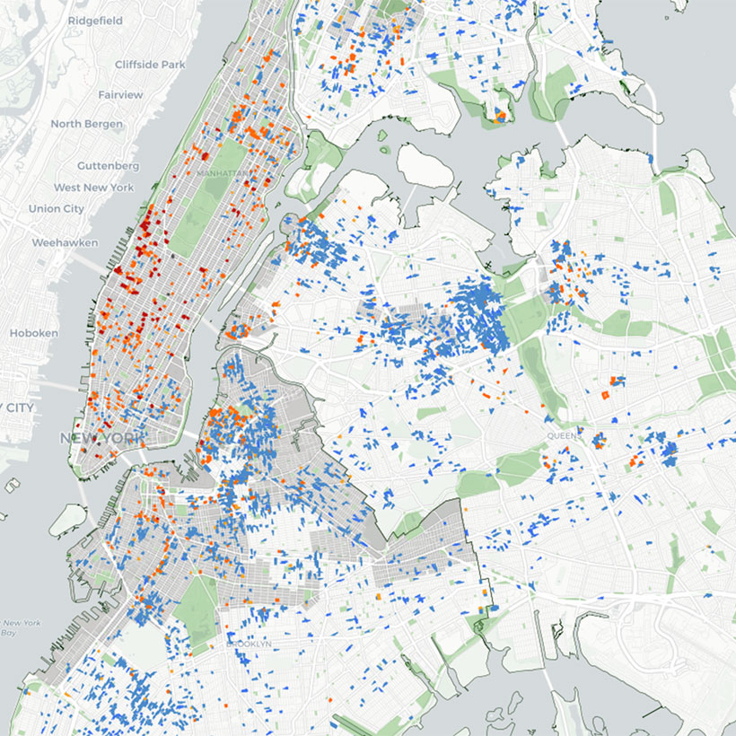
Cumulative Impacts – In addition to the EDC and LIC Core projects, the Long Island City area is expected to see substantial growth fostered by numerous zoning changes approved in the area over the past decade (Figure 3). These actions have already substantially increased the area’s population. For example, Queens Census Tract 1 – the location of the Anable Basin Rezoningexperienced a 261 percent population increase between years 2000-2010.
This increase can be partially attributed to the creation of the Southern Hunters Point Special District in 2008. According to project documentation, approximately 2,000 residents will have moved into the Special District by the year 2025. This will also increase population in the Anable Basin project area during an overlapping timeframe (2020-2034). 2
The Cornell Tech Campus on Roosevelt Island is another nearby development to consider in the DEIS cumulative impacts evaluation. It is expected to add 5,400 people (3,203 academic/research and 2,228 workers) to the area by 2038. This anticipated growth also overlaps with the development period of Anable Basin Rezoning.
Based on these factors, the DEIS must take into account substantial population increases and create a proper framework to evaluate the cumulative environmental impacts of all the ongoing projects in the Anable Basin Project area.
Public Policy – Flood Risk
The project area is within the FEMA-designated high-risk flood zones and zones expected to receive 1.5-foot or greater breaking waves. 3 Therefore, the DEIS must identify and evaluate specific strategies for how the project will address climate change impacts, storm surge resiliency, and flood mitigation in the waterfront areas, as part of the Waterfront Access Plan (WAP).
In addition, given that the project area is also within the City and State-regulated Coastal Zone, the DEIS must provide an assessment of the project’s consistency with the NYC Waterfront Revitalization Program (WRP). Consistency with WRP Policy 6 is particularly important because 75 percent of the buildings (912 out of 1,206) within one-half mile of the project area are in the projected 2050 100-year flood zone (Figure 4), according to the New York Panel on Climate Change (NPCC). Therefore, it is critical that the DEIS identify and evaluate specific measures that reduce the impacts of climate change and storm surge in the project area and how the project would avoid increasing flood risk to neighboring properties and buildings within the broader study area.
We also expect the DEIS evaluation to include proposed flood resiliency measures for existing and proposed buildings within the half-mile study area, as well as infrastructure improvements to the riverfront area, corridors connecting the waterfront to the rest of the neighborhood, and access points to the river. We recommend the implementation of soft edge approaches such as green infrastructure and salt marsh restoration for wave attenuation, whenever possible.
Community Facilities and Services – Schools
Schools in Queens School District 30 are already overburdened. According to the Independent Budget Office (IBO), District 30 needs approximately 3,400 additional seats to reduce overcrowding. 4 In itself, the Anable Basin Rezoning is expected to add approximately 2,700 school age children to the area.
Although the proposal includes one new offsite public school with a total of 728 new seats, the DEIS must evaluate current and future public school utilization rates to accurately evaluate school capacity in light of the rezoning proposal. The evaluating must consider the cumulative incremental population increases projected for the entire study area to determine if these additional school seats sufficiently accommodate the projected growth.
If the DEIS indicates area schools remain overcrowded, clear mitigating measures, included funding sources and the potential for additional schools, must be identified.
Open Space
The addition of approximately 12,900 residents and 2,700 workers is expected to place significant demand on existing open space resources in the project area. According to the DSOW, the project would substantially exceed the respective residential and worker CEQR thresholds requiring additional analysis.
Therefore, the DEIS must include a detailed quantitative and qualitative evaluation of the impacts of the project on open space, including appropriate mitigation measures that address the expected open space shortfall and increase in demand.With the anticipated new population and merely 135,000 sf of open space proposed under the rezoning, the project area will remain well below the city goal of 2.5 acres open space per 1,000 residents.
Additionally, we have concerns about the proposed open space. Based on our estimations, the shore public walkway, required under the Hunter Point WAP, would create approximately 75,000 sq ft of new open space. However, it is not clear from the DSOW if the remaining 60,000 sq ft would come from the upland connections and flexible lane zones or another area.
Furthermore, according to the development massings under the RWCDS in the DSOW, the upland connections, particularly on Site G, and some of the flexible lane zones, are depicted as being built out. To clarify what is actually being planned, the DEIS must include a detailed open space plan that clearly shows the relation between the flexible lane zones, upland connections, and the projected building massings. Otherwise, by our calculations, the open space increment would be approximately 75,000 sq ft, instead of 135,000 sq ft.
Finally, given the lack of open space in the study area and the increased demand expected with the new residential and worker population, the DEIS must evaluate impacts on the proposed shore public walkway, including but not limited to, shadows, utilization rates, flood risk, and hazardous materials.
Shadows
With the height and proximity of the proposed towers under the rezoning, significant shadow impacts are expected on open space and the East River (further discussed under “Natural Resources”).
Based on our preliminary shadow analysis for the March 21 evaluation period that uses the building massings under RWCDS I, significant incremental shadows would occur on the East River during morning hours, particularly from the towers on development sites A1 and A2. The Basin itself and the proposed waterfront shore public walkway will also incur incremental shadows in the late morning from the mid-size towers on development sites B1 and B2. Significant incremental shadows are also expected from development sites A4 and F1, which will affect the Gordon Triangle, a plaza operated by the Department of Parks and Recreation, one block east of the project area, in the early afternoon (Figures 5 and 6).
Based on the expected impacts, the DEIS must identify clear mitigation measures that eliminate or reduce shadow impacts to the greatest extent practicable. We also expect that the DEIS shadow analysis will indicate the specific buildings that would create the incremental shadows affecting the East River, as well as newly created and existing open space resources.
Natural Resources
Because significant incremental shadows on the East River are expected, the DEIS natural resources evaluation must examine impacts on specific marine species and habitats. If in-water work is needed and State and Federal wetland permits are required, the analysis must include a summary of a new Essential Fish Habitat Study (EFHS) to accurately evaluate the potential impacts on ecological conditions in the river. If applicable, we also request that the DEIS to include the EFHS report and the State and Federal wetland permit applications and correspondence with DEC and the US Army Corps of Engineers in the DEIS appendix.
Hazardous Materials
Because of the historic manufacturing and industrial land uses in the project area, many sites within the rezoning area have entered into the State’s Brownfield Cleanup Program. Therefore, the DEIS hazardous materials evaluation must summarize the findings of Phase 1 Environmental Site Assessments and Phase 2 Environmental Site Investigations completed in the rezoning project area.
In addition, the DEIS must address toxic sediments in the basin that are being re-suspended by ferry wake. Service on the Astoria ferry route began on August 29, 2017. According to the schedules of NYC Ferry, the Long Island City stop at Gantry Plaza State Park sees over 20 boats arriving and departing each weekday. The ferry landing is less than 500 feet from the basin’s entrance. The frequency and proximity of ferry activity to the basin suggests that toxic sediments are being re-suspended from the basin’s floor, risking the health of people recreating along the proposed shore public walkway and those in contact with water.
The evaluation must discuss the expected and approved remediation actions required under the Brownfield Cleanup Program that would bring the applicable sites into compliance for redevelopment. We also request that copies of all environmental reports are included in the DEIS appendix. This is particularly important given the potential siting of new public schools on currently contaminated property and residents accessing the waterfront where potential re-suspended toxic sediments would compromise water quality.
Water and Sewer Infrastructure
The proposed project would significantly exceed CEQR thresholds that require a detailed water and sewer infrastructure analysis. Therefore, the DEIS must evaluate the impacts of the rezoning on the treatment capacity of the Bowery Bay Wastewater Treatment Plant (WWTP) and the Combined Sewer Overflows (CSO) from outfalls BB-021, BB-022, and BB-023.
The project area is within the sewershed of the Bowery Bay WWTP, which has been operating since 1939. According to the NYC Department of Environmental Protection (DEP), the plant was designed to treat 150 million gallons of wastewater a day, and currently serves a population of approximately 850,000. Recent upgrades to the plant were aimed at reducing odors, not increasing the plant’s treatment capacity. Based on water consumption rates in New York City during 2016, and the sizable population increase resulting from the project, daily water consumption is expected to increase by almost two million gallons per day, or 1.3 percent of total treatment capacity at the Bowery Bay WWTP. This increase is roughly the equivalent to the amount of water consumed per day in Red Hook, Brooklyn (Census Tracts 53, 59 and 85).
The total area under the rezoning project site is over 670,000 sq ft, which exceeds CEQR thresholds requiring a detailed analysis by a factor of three. Even when the new proposed open space is considered, over one half million sq ft of the project area surface would remain impervious.
To demonstrate the potential stormwater impacts of the proposal, in a one-inch storm event, this area would generate over 330,000 gallons of stormwater runoff, resulting in combined sewer overflows into the East River and Anable Basin. Based on DEP model data, outfall BB-022 had 18 overflow events, which resulted in over 1 million gallons of raw sewage and stormwater spilling into Anable Basin in 2016 alone. Furthermore, outfalls BB-021 and BB-023 resulted in at least 26 overflow events each, and together spilled over 29 million gallons of wasterwater in 2016.
Based on these conditions, it is critical that the DEIS includes a detailed analysis of sustainability measures and best management practices that will be employed to reduce water consumption, stormwater runoff, and CSO overflow events and compare them to minimum requirements for LEED™ or an equivalent environmental standard.
Energy, Air Quality and Greenhouse Gas Emissions
We expect that the DEIS energy evaluation will go beyond merely disclosing the projected energy demand of the new development under the rezoning. Based on the magnitude of the development expected, the evaluation should analyze the energy efficiency of the proposed developments in comparison to minimum requirements for LEED certification or an equivalent environmental standard.
The DEIS should also provide a detailed analysis of the sustainability measures that will be employed to reduce greenhouse gas emissions and urban heat island effect, consistent with New York City public policy, including but not limited to, design guidelines that promote sustainable demolition and construction methods, green roofs, tree planting, new open space, and state-of-the-art energy efficient HVAC equipment. MAS recommends for these and other environmental factors to be evaluated as an Optimal Sustainable Development Scenario alternative that demonstrates application of sustainable practices at the highest feasible standards.
Furthermore, as mentioned in our discussion regarding the WAP, because the development under the rezoning will occur within the 100-year floodplain, with many street elevations significantly below the base flood height, we expect the DEIS will include detailed drawings and descriptions of the resiliency design measures that will be implemented under the plan.
Traffic and Transportation
The projected incremental increase of more than 15,000 residents to the study area will strain existing transit infrastructure, affect traffic patterns, and increase greenhouse gas emissions. The nearest transit stop in the project area is the Court Square complex, slightly more than 1/3-mile away, which includes the E, G, M, and 7 lines. Between 2011 and 2016, weekday ridership at the Court Square station increased by almost 8 percent 5, with the E and 7 trains running at maximum capacity during peak morning rush hours. 6 Given the anticipated increase in population and ridership, the DEIS must identify clear and realistic mitigation measures that address impacts at Court Square station.
We expect the transportation analysis will evaluate the project’s impacts on ferry service in the vicinity of the project area.Although many new residents and workers are likely to use the ferry instead of the MTA, we are concerned about the capacity of the ferry service to accommodate the added demand. As of December 31, 2017, the NYC Ferry had served approximately 2,890,000 riders, almost 34 percent more of the anticipated 2.1 million 7. According to information provided by NYC Ferry, over 20 boats arrive and depart each weekday at the Long Island City stop at Gantry Plaza State Park.
If the analysis shows adverse impacts on ferry service capacity, the DEIS must evaluate new express routes that serve the Long Island City ferry stop and/or an increase in ridership capacity for the existing Astoria route.
Construction Impacts
Given the scale of the expected development, the multiple construction sites, the 15-year construction period, and the substantial construction that will occur near the proposed EDC school site, the construction analysis must include details on the timing and sequencing of construction activities in relation to other projects in the area, as well as an evaluation of construction traffic, air quality, and noise on nearly residences, schools, and hospitals. We also expect a robust evaluation of mitigation measures to address the construction impacts.
Conclusion
The Anable Basin Rezoning proposal will bring about a massive increase in development and population to the Long Island City waterfront. The environmental impacts are expected to be significant. When these impacts are considered in concert with the planned EDC development and the LIC Core rezoning, and with the understanding of the population growth that is currently occurring in Long Island City, it is incumbent upon the City to conduct a comprehensive coordinated review that takes into account the full cumulative environmental impacts of these actions in Long Island City.
We remain steadfast in our concerns about segmenting the environmental review. The risks of separately evaluating these actions may result in severe unmitigated environmental impacts that will harmful long-term effects in Long Island City for generations.
In taking a comprehensive approach to the environmental review, we hope the City sees the opportunity to create a truly complete and livable neighborhood along the Long Island City waterfront. Given the scale and potential for long-term adverse impacts on the Long Island City area, Plaxall Plastics must engage in meaningful community engagement before the rezoning proposal can be advanced.
MAS recognizes the importance of accommodating growth in the city, and believes the Anable Basin area and Long Island City in general provide the necessary conditions to foster well-planned and managed growth. However, in order to ensure this vision, it is paramount that all environmental factors are addressed comprehensively.
Thank you for the opportunity to provide comments on the DSOW.
Notes
- Response letter from City Planning Commission chair Carl Weisbrod regarding Pre-Application Statements (PAS) for Two Bridges Manhattan Block 246, 247, and 248. August 11, 2016
- Technical Memorandum 005 CEQR Number 08DME006Q Hunter’s Point South Rezoning and Related Actions. November 30, 2017
- 100-year floodplain according to 2007 effective Flood Insurance Rate Maps (FIRMS) and areas within Limit of Moderate Wave Action (LiMWA) according to 2015 preliminary FIRMS
- Testimony of Sarita Subramanian Senior Education Budget and Policy Analyst, New York City Independent Budget Office to the New York City Council Education Committee on Overcrowding in the City’s Public Schools and Plans for Increasing Capacity. March 3, 2015.
- MTA, “Facts and Figures,” 2016.
- NYPIRG Straphangers Campaign, “State of the Subways Report Card,” 2016.
- The New York City Economic Development Corporation (NYCEDC) and Hornblower, operator of the NYC Ferry system ridership numbers for inaugural season. Released January 11, 2018.
Help us continue our planning advocacy on behalf of New York City.
DonateRelated Initiatives
Related News + Reports