Outlining Serious Concerns regarding 250 Water Street Proposal
Testimony to the Department of City Planning
The Municipal Art Society of New York (MAS) has been closely involved with South Street Seaport’s evolution since 1965. Through testimonies, articles, letters, and events, MAS has been one of the most vocal supporters of protecting the Seaport. From the designation of Schermerhorn Row in 1968 to the recent reconstruction of the Tin Building, we remain dedicated to preserving the authentic maritime character of New York City’s first financial district.
It is from this perspective that we raise serious concerns about the current proposal by Howard Hughes Corporation (250 Seaport District LLC) to redevelop 250 Water Street. The New York City Department of City Planning (DCP) issued a Draft Scope of Work (DSOW) for a proposed 470-foot-tall mixed-use building that would include 912,762 gross square feet (gsf) of market-rate and affordable housing, retail, office, community spaces, and parking. As part of the proposal, the applicant also seeks a special permit to allow bulk modifications and distribution of City-owned development rights from Pier 17 and the Tin Building to the development site. The proposal would facilitate the financial stabilization, restoration, reopening, and potential expansion of the South Street Seaport Museum (the museum) by providing $50 million in funding.1 According to the DSOW, the survival of the museum is contingent on the proposal going forward.
Download Testimony
The current proposal is just one of several attempts over the last forty years to develop the project site. The South Street Seaport Subdistrict was rezoned in 2003 to adjust the underlying zoning to be more consistent with the South Street Seaport Historic District. The C6-2A contextual zoning, which imposed a height limit of 120 feet, was designed to strengthen the existing neighborhood context by mandating a built form similar to the surrounding buildings while allowing medium-density residential and commercial development. MAS supported the Community Board’s original 2003 rezoning application and continues to maintain that the City’s historic zoning policy for the Seaport be respected.
On January 5, MAS testified before the Landmarks Preservation Commission (LPC) urging that a Certificate of Appropriateness for the project be denied (see attached testimony). In addition to concerns about appropriateness within the historic district in terms of design and scale, MAS has fundamental problems with the proposed development from a policy perspective, particularly regarding the transfer of City-owned development rights upon which the project depends. Based on the 2003 amendment to the Special District, the project site is not a designated development rights receiving site and Pier 17 and the Tin Building are not mapped as development right granting sites. These sites need to be mapped as receiving and granting sites as part of the proposed action, before any substantive discussion on the merits of the proposal moves forward. No FSOW should be issued that does not address this issue.
From an environmental review perspective, we have the following comments, which we look forward to being reflected in the Final Scope of Work (FSOW) and included in the Draft Environmental Impact Statement (DEIS).
Project Description
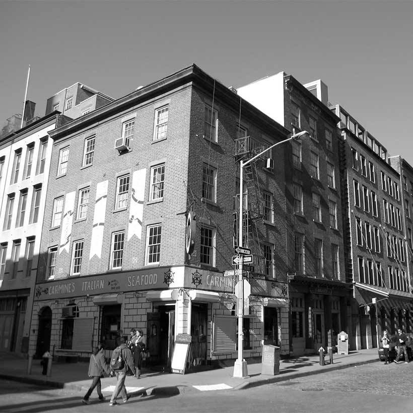
The 48,000 square-foot project site is composed of 250 Water Street (Block 98 Lot 1), currently a 400-space surface parking lot that occupies the full block bounded by Pearl Street, Water Street, Beekman Street, and Peck Slip, the 21,500-square-foot South Street Seaport Museum site (a portion of Block 74, Lot 1 between John Street, South Street, and Fulton Street), and the museum’s “collections” building (the AA Low Building) midblock on John Street. The project site also includes additional areas that according to the DSOW may undergo streetscape, open space, and other improvements under the requested special permit.2
250 Water Street
The proposal seeks a special permit for bulk modifications, a development rights distribution from the Pier 17 and Tin Building lots, possible zoning text amendments to the special permit and special purpose district text, and an authorization for a curb cut on Pearl Street. Additionally, according to the DSOW, other actions may include dispositions authorizing the sale of development rights and funding decisions, if required, to effectuate other changes to the affected area. The DEIS must expand upon this last point and disclose details concerning what other disposition actions for the sale of development rights are needed to facilitate the proposed project. We also urge the City to revise the scope so that the mapping amendments and disposition process needed to facilitate this project become part of the proposed action; specifically, the mapping of 250 Water Street as a receiving site and Pier 17 and the Tin Building as granting sites.
The actions would allow approximately 640,186 gsf of residential uses, including 360 market-rate units, of which 25 percent (90 units) would be affordable under Mandatory Inclusionary Housing (MIH), 257,886 gsf of office space, 9,690 gsf of retail uses, 5,000 gsf of community facility uses, and 128 parking spaces. A seven-story podium (approximately 100 feet tall) would include mixed uses, on which two 37 and 38-story towers sit above, containing residential uses, for a total height of approximately 470 feet. We understand that for the purpose of a conservative analysis, the DEIS will evaluate a development scenario that includes 640 dwelling units, 160 of which would be affordable under MIH, and all dwelling units would be 1,000 gsf in area.
South Street Seaport Museum
This proposal also seeks to facilitate the restoration, reopening, and potential expansion of the existing South Street Seaport Museum. The restoration of the museum includes approximately 27,996 gsf of renovated space in the Fulton Ferry Building at the corner of Fulton Street and South Street. The proposed expansion would facilitate a seven-story (approximately 62-foot tall) 32,383 gross-square-foot building on the vacant lot at the corner of Burling Slip/John Street and South Street.
To clarify this proposal, the DEIS must disclose information concerning the South Street Seaport Museum’s current financial outlook. We question the reliability of the Reasonable Worst Case Development Scenario (RWCDS), which states “absent the proposed actions, the museum would be closed in the future.” Therefore, the DEIS must disclose financial information concerning the museum’s current budget for the museum expansion (without the dedicated funds), the specific amount Howard Hughes proposes to allocate to the museum, and to what museum expense the funds will be dedicated (i.e., whether the funds will go towards a capital campaign or the museum’s endowment). The DEIS must also disclose the legal mechanism by which the museum will secure the funding from Howard Hughes and when the funding will be provided. It should also disclose any vulnerabilities that might affect the disposition of the funds, i.e, are there any circumstances in which the funding would not be provided if the project is approved. Lastly, the DEIS must disclose information about how the assumed 2026 build year for the museum expansion was calculated.
Land Use, Zoning, and Public Policy
MAS urges DCP not to depart from the City’s historic zoning intent of the Seaport and to critically evaluate the negative policy implications of designating 250 Water Street as a receiving site.
Although the applicant presents this proposal as adhering to the historic objective of the district and helping to preserve and maintain its low-scale character, in reality we find it is the opposite. In 1972, the City created the Special South Street Seaport District to maintain the historic context and facilitate the transfer of development rights outside the district. 250 Water Street was included in the district but was not designated a receiving site. Moreover, when the South Street Seaport Historic District was created in 1977, the boundaries were carefully drawn to protect the existing character and manage future development in the neighborhood. To that end, a number of vacant lots were included in the designation, specifically 250 Water Street. Meanwhile, several buildings contributing to the period of significance were excised by the Board of Estimate and later formed the 1989 district expansion. This underscores the intention behind including 250 Water Street in the original historic district to regulate the character of new development. Lastly, the Community Board’s 2003 rezoning was passed with the goal of better aligning the zoning with the City’s original intent of the historic district by shrinking the FAR and envelope to better reflect the neighborhood context. The C6-2A district limits building height to 120 feet and an FAR of 6.02.
If permitted, the 470-foot-tall towers would significantly depart from the City’s zoning intent and subsequently lead to negative citywide implications in historic districts. Howard Hughes has made a case that the context for this site is the surrounding towers of Lower Manhattan. However, there is no such thing as an “edge” or “transition” in a historic district, a given lot of land is either included inside or outside of the boundaries. Furthermore, the land use rationale for transferring floor area off block was to preserve the granting site. In this case, however, the granting site is Pier 17/Tin Building, which is not considered as the beneficiary of the land use action at hand.3 For the long term, MAS is also deeply concerned about the precedent of allowing the transfer of a City asset to a private developer for subsequent reallocation to the South Street Seaport Museum. The original intent of the subdistrict was to have the development right transfers benefit the museum. However, with the proposal, it appears the development right transfers would benefit a private developer first, then City, and finally the museum.
Therefore, the DEIS must identify and disclose all the unused floor area from the Pier 17/Tin Building lots that are proposed to be transferred to 250 Water Street, in addition to their value and the legal process of facilitating the development rights transfer. The DEIS must disclose any other anticipated development rights transfers, including the source and amount of rights. Additionally, the DEIS must disclose the remaining amount of air rights in the district and discuss the status and role of the New Market Building in the development rights transfer. Lastly, the DEIS must disclose and explain the mapping actions that would facilitate 250 Water Street as a receiving site and Pier 17/Tin Building as granting sites.
Socioeconomic Conditions
According to the applicant, this development will be the first MIH project in Lower Manhattan. While we acknowledge the importance of building affordable housing throughout the city, especially in high-opportunity areas such as Community Board 1, this proposal is offering only what is required under MIH, and therefore, no special forbearance should be anticipated by the developer.
We recommend that the DEIS disclose and evaluate the affordability levels being considered under MIH. Moreover, the DEIS must disclose how the market-rate and MIH units will be distributed throughout the two towers in the proposed development. According to the DSOW, the average dwelling unit size would be 1,000 square feet. However, the applicant, as stated, intends to construct larger units which would yield a lower number of market-rate (360) and affordable units (90). The DEIS must disclose the breakdown of the number of bedrooms being proposed for all dwelling units.
Open Space
For a project that touts community benefits, we question the overall lack of publicly accessible open space and attention to the public realm. We strongly recommend that more open space be provided, and that it be publicly accessible 24 hours a day. We also recommend that the DEIS include a detailed site plan showing the proposed layout and amenities of the public open space, particularly at Peck Slip between Water Street and Pearl Street, which is part of the project area.
Shadows
The proposed project will likely cast significant shadows on nearby parks, open spaces, and other historic resources in the Seaport, namely Pearl Street Playground, Peck Slip, and Titanic Memorial Park. The DEIS must describe in detail the specific shadow impacts on publicly accessible parks and plazas, historic resources, and natural resources.
Historic and Cultural Resources
Since the development site and museum site are located within the South Street Seaport Historic District, significant impacts are expected on historic and cultural resources. We recommend the DEIS include the Phase IA archaeological study to disclose potential archaeological resources on the John Street lot, specifically the artifacts from the Ronson ship, an 18th-century British merchant ship discovered under 175 Water Street in 1982. Additionally, the DEIS must provide a detailed conservation plan for Schermerhorn Row.
Urban Design and Visual Resources
The proposed 470-foot-tall towers sited in a historic district where the tallest building is 104 feet and the average building height is 57 feet, and in a zoning district with a height limit of 120 feet raises serious concerns about the out-of-scale nature of the project, the negative implications for the pedestrian experience, and its potential to block critical view corridors of historic resources. As part of the urban design analysis, the DEIS must include detailed drawings of all streetscape, open space, and other improvements being requested under the special permit. For the evaluation of potential visual resource impacts, the DEIS must provide photo stimulations looking toward the East River, Brooklyn Bridge, and other historic buildings in the Seaport and an evaluation of the potential for the proposed development to block these important view corridors. In addition, the DEIS analysis must identify specific mitigation measures to avoid potential adverse impacts.
Climate Change Impacts
The southern portion of the development site and the museum site are within the 100-year floodplain. The site is also in the State and City-regulated coastal zone and will require an evaluation of its consistency with the City’s Waterfront Revitalization Plan. Therefore, the DEIS must disclose and evaluate these risks in detail. Given the fact that the area flooded during Hurricane Sandy in 2012 and remains at risk, the DEIS must also provide details on resiliency and mitigation measures, including those pertaining to sea level rise and storm surge. We expect the analysis to examine the impacts of climate change based on sea-level rise and flooding estimates by 2080, consistent with standards established by the New York City Panel on Climate Change. The DEIS should also disclose how the project will be affected by the proposed Zoning for Coastal Flood Resiliency, which is currently in public review.
Hazardous Materials
Based on prior use, the project site is heavily contaminated and would need to be remediated before any construction activities can proceed. The owner has voluntarily entered the project site into the New York State Brownfield Cleanup Program. For full disclosure of all potential hazardous material impacts and findings, the DEIS must include the Phase I Environmental Site Evaluation, and if completed, the Phase II Environmental Site Investigation reports. The DEIS evaluation also must include all relevant information regarding the Remedial Action Plan and detailed measures for protecting workers, visitors, and occupants during project construction and operation.
Neighborhood Character
The proposed project is within the South Street Seaport Historic District, which is characterized by low-rise, commercial buildings from the 19th Century. However, since the proposal would substantially exceed the district’s zoning height limits, it is not consistent with the area’s neighborhood character. The DEIS must evaluate how the 470-foot dual towers above the podium would be consistent with the low-scale character of the district.
Alternatives
The alternatives chapter in the DEIS must identify and evaluate a lower-scale alternative that would provide affordable housing without utilizing City-owned development rights. The evaluation should also consider an alternative that excludes the museum as part of the proposal. (The museum improvements and expansion could be considered in an independent action.) Additionally, the alternatives analysis should include a future in which absent the proposed project, the museum is still able to operate.
Conclusion
We recognize that the economic and physical climate of this area has evolved since the original Seaport District was established in 1972. We also recognize that the project site should not remain a barren parking lot. However, we strongly urge that the principles embodied in the City’s zoning policy actions for more than 40 years be respected. The current proposal at 250 Water Street has the potential to drastically change the unique historic and urban design character of the area. Additionally, questions concerning the South Street Seaport Museum’s funding must be addressed before any substantive discussion on the merits of the proposal moves forward. Therefore, we strongly urge that the comments above be reflected in the FSOW and included in the DEIS.
Notes
- 6sqft.com
- These areas include Titanic Park, Pier 16, Peck Slip between Pearl and Water Street, Water Street between Fulton Street and Peck Slip, Front Street between John Street and Beekman Street, and Fulton Street between Water Street and South Street. The project area also includes the Pier 17 Large-Scale General Development.
- CPC Report C 020213 ZMM, page 22: “First, within the Seaport district, the basis for designation of a site as a granting lot is that there is a historical resource on that lot that merits protection through the alleviation of development pressure on that site.” In this case, Pier 17 does not match this criteria.
Testimony from the Municipal Art Society of New York to the Landmarks Preservation Commission Regarding 250 Water Street
The Municipal Art Society of New York (MAS) has had a long engagement with the Seaport, dating back to the conceptualization of the South Street Seaport Museum in 1965. Since that time, we have participated in every major land use action in the district, from the designation of Schermerhorn Row in 1968 to the recent reconstruction of the Tin Building. For more than 50 years, we have been dedicated to the preservation of the authentic maritime character of New York City’s first financial district. We have attached a brief synopsis of positions that MAS has taken that are relevant to the one before you today.
The Landmarks Preservation Commission has before it the tenth proposal for 250 Water Street, nine of which have been found failing by previous Commissioners. Despite the desire to bring forward a project that has strong community benefits and a will to do right by the urban design challenges of the site, this proposal is unsupportable. The Municipal Art Society of New York urges the Commission to reject it on the following grounds.
The Commission must uphold the boundaries of the South Street Seaport Historic District.
The Howard Hughes Corporation, the developer of 250 Water Street, has made a case that the context for this site is the surrounding towers of Lower Manhattan. However, there is no such thing as an “edge” or “transition” in a historic district, a given lot of land is either included inside or outside of the boundaries.
As you all know, the South Street Seaport Historic District was designated in 1977. The boundaries were carefully drawn to protect the existing character and manage future development in the neighborhood. To that end, a number of vacant lots were included in the designation, specifically 250 Water Street. Meanwhile, several buildings contributing to the period of significance were excised by the Board of Estimate and later formed the 1989 district extension. This underscores the intention behind including 250 Water Street in the original historic district to regulate the character of new development.
The vacant lot at 250 Water Street was always intended to be developed, and still can be.
To date, the Commission has carefully regulated this district to ensure that its low-rise nature would be retained even as new developments have been built within its boundaries. Indeed there have been successes, including James Polshek’s Seamen’s Institute and the Front Street development by Cook + Fox Architects. These projects have shown how new architecture in the district can enhance the neighborhood’s character and its vitality. An appropriate proposal for 250 Water Street would engage the existing architecture in an equally creative way, remaining consistent with the sense of place of the South Street Seaport Historic District.
The bulk of the proposed towers is not consistent with allowable density on the site.
The Commission has approved only one development scheme for this site, a 10-story building with a penthouse, totaling roughly 380,000 square feet. In 2003, the Seaport neighborhood was contextually rezoned, roughly matching this envelope. At the time, we commented to the City Planning Commission, “The proposed zoning would also permit a height of up to two stories greater than the District’s tallest existing building. It remains true today, that an as-of-right building conforming to the zoning can meet the needs of both growth and preservation in the Seaport.
While Skidmore, Owings, and Merrill has designed a podium for 250 Water Street that seeks to respond to the context of the low-rise neighborhood, the proposal before you today is vastly inappropriate for a historic district in which the tallest building is 104 feet, and the average building height is 57 feet. The Commission must review this development with the same level of rigor as it has done for other applications on this site and within the South Street Seaport Historic District overall.
The community benefits do not justify a development that will undermine the character of the historic district.
Proponents have made an emotional appeal for this project, tethering the development at 250 Water Street to the fate of the South Street Seaport Museum. The survival of the museum demands the City’s attention and deep commitment, as the very interdependence of the museum and the historic district was designed in from the beginning.
And yet, approval of this project would upend the very grand purpose that museum’s founders set out to achieve. Our 1981 issue of the Livable City was devoted to the topic of the Seaport reminds us of the stated intention for its creation. “The Museum itself was a maverick. Its collection would not be made up of paintings or coins or things in cases with labels. Its treasure was to be a piece of the City: the buildings that stood within its boundaries, the ships moored at its piers… It was obvious that certain new infill structures would have to be built, and it was understood that the new buildings would fit in, respecting the scale of the existing neighborhood; they would not overwhelm it.”
It is long overdue for the City to make good on its responsibility to secure futures of both the museum and the historic district. However, instead, today’s proposal offers two towers that are more than 10 times the size of any building in the district, using City-owned air rights that could and should be deployed elsewhere and for a more direct benefit of the museum.
We respect the investment that the Howard Hughes Corporation is proposing to make in the museum as part of this project. Yet, the circumstances of their largesse is largely a made possible by the transfer of a City asset to a private developer for subsequent reallocation to the South Street Seaport Museum. While the Commission must make its decision solely on the appropriateness of the proposal, it must also be recognized that the conundrum before it is one of the City’s own making.
We also acknowledge the importance of building affordable housing throughout the city, and especially in more well-to-do neighborhoods such as Lower Manhattan. But in the end, this proposal is offering only what is required of it under Mandatory Inclusionary Housing, and therefore, no special forbearance should be anticipated by the developer. Surely the City must find a way to thread these very important public policy needles without negating one for another.
In New York City, change is the only constant. We acknowledge that the economic and physical climate in the historic district provide a very different context than existed in 1977 at the time of designation, or 2003 during the downzoning, or the years between when various proposals for the site came before the Commission. The question is not whether that change is good or bad, but whether the principles that have been embodied in the City’s policy actions for more than 40 years should be modified to reflect those vicissitudes.
This decision is one that will have far-reaching implications for the evolution of historic districts and the intricate interplay of contemporary and historic architecture. We implore the Commission to consider the precedents with great care in determining their validity in the context of today.
We maintain that this approach provides a convoluted and treacherous conclusion that is gravely flawed for the historic district, and is ultimately damaging to the museum it purports to save. We respectfully urge the Commission to reject the proposal for 250 Water Street.
Comments from the Municipal Art Society of New York on Previous Proposals for 250 Water Street
In 1990, when a 12-story building designed by a long-time board member of MAS (and former LPC Commissioner), we testified:
- “…the mass of the building is strikingly out of scale with the buildings that characterize the South Street Seaport Historic District.”
- “This site was purposefully included in this historic district and should not be treated as transitional. The same rules of appropriateness should be applied to this site as are applied to other sites within the district.”
- “…the Landmarks Preservation Commission has the power and responsibility to regulate new development within a historic district, including scale, in order to protect the character of that district.”
In 1996, we commented on a scheme for two towers (32 and 14 stories) by the same architects. “The District perceptually will have been reduced in size by a square block. The looming towers of Downtown will have moved not only closer to the District but actually into it. And neither façade decoration nor modest reductions in height will disguise or mitigate the effects of that incursion.”
When that proposal was modified, we maintained our position. “The Preservation Committee has voted to oppose the project, reiterating the Society’s belief that a building of this scale, size and disposition would be incompatible with the district; would intrude into important sight lines from the Brooklyn Bridge and elsewhere; would interfere with the district’s characteristic roofscape; and would diminish its perceived extent by introducing tower elements characteristic of other areas of Lower Manhattan but alien to the South Street Seaport Historic District.”
Testimony from the Municipal Art Society of New York to the Landmarks Preservation Commission Regarding 175 John Street
Sentiments about the proposed new building at 175 John Street, expanding the South Street Seaport Museum, were mixed among MAS Preservation and Planning Committee members. Some felt that the copper cladding and glass reveal were misplaced in the context of centuries-old masonry buildings, while others supported the more contemporary approach in materials and setback. Some committee members questioned the detail of the conservation plan for Schermerhorn Row, arguably the most important structures in the district.
However, there was consensus that the scale and massing of the new building are appropriate to the site and district. The committees felt that the relocation of the museum entrance is a smart programming and urban design move. There was also appreciation for the sustainability measures being undertaken, and the reflection of the neighborhood’s maritime history in the timber-framed interior.
Several committee members noted a missed opportunity to reconstruct and display the bow of “The Ronson,” an early-18th-century merchant vessel that was uncovered on the John Street lot. Indeed, there may be other archeological treasures to be found and exhibited in the museum.
Overall, MAS encourages the LPC to approve 175 John Street, assuming a detailed plan for excavation is incorporated.
Help us continue our planning advocacy on behalf of New York City.
DonateRelated Initiatives

Supporting New Yorkers to become stronger advocates for their neighborhoods

Related News + Reports